Tilicho Lake and Annapurna Circuit Trek - 15 Days 15 Days
USD 1,690
USD 1,590 per person
| Activities | - | Fitness Level | Moderate |
| Max Elevation | 5416m | Commute | Kathmandu to Pokhara |
| Best Month | Autumn,Spring,winter | Group Size | Min: 2, Max: 10+,single |
| Arrival on | Kathmandu | Depart From | Kathmandu |
| Meal | B L D | Duration | 15 Days |
| Stay | Hotel & Tea House | Price | USD 1,590 per person |
Overview
The Tilicho Lake and Annapurna Circuit Trek is one of the most complete trekking experiences available in the Himalayas. In fifteen days, this route combines two of Nepal's most celebrated high-altitude highlights: a side excursion to Tilicho Lake at 4,919 metres and the crossing of Thorong La Pass at 5,416 metres. Few treks on earth reward trekkers with two distinct summit moments of this magnitude within a single itinerary.
The Annapurna Circuit follows the Marsyangdi River valley northward through terraced farmland, dense rhododendron forests, and Tibetan-influenced villages before climbing into the high-altitude rain shadow region of Manang. The addition of Tilicho Lake transforms this already exceptional trek into something rarer: a full circuit of the Annapurna massif that reaches a glacially formed lake sitting in a dramatic bowl of peaks and ice, with no comparable lake accessible to trekkers at this altitude anywhere in the region.
The route then rejoins the main circuit and continues to the Thorong La Pass crossing before descending into the Mustang plateau, ending with a short flight from Jomsom to Pokhara. The combination of lush subtropical valleys, high alpine terrain, sacred Hindu and Buddhist sites, and the contrasting arid landscape of the Kali Gandaki gorge makes this itinerary one of the most geographically and culturally diverse treks in Nepal.
Outline Itinerary:
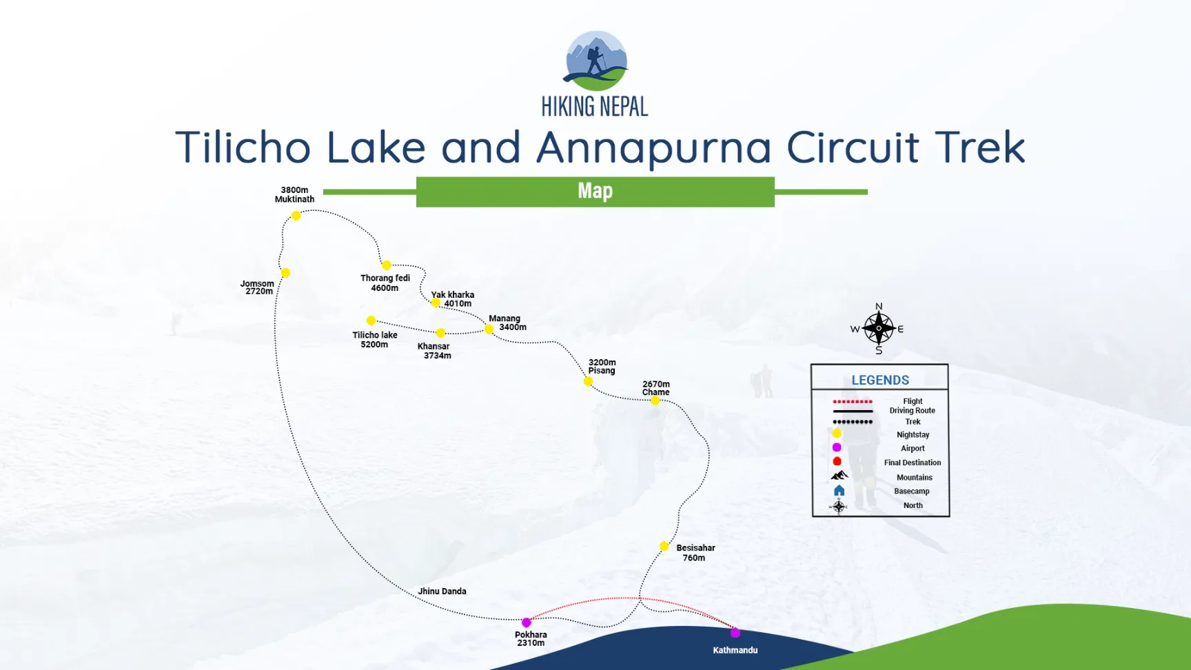
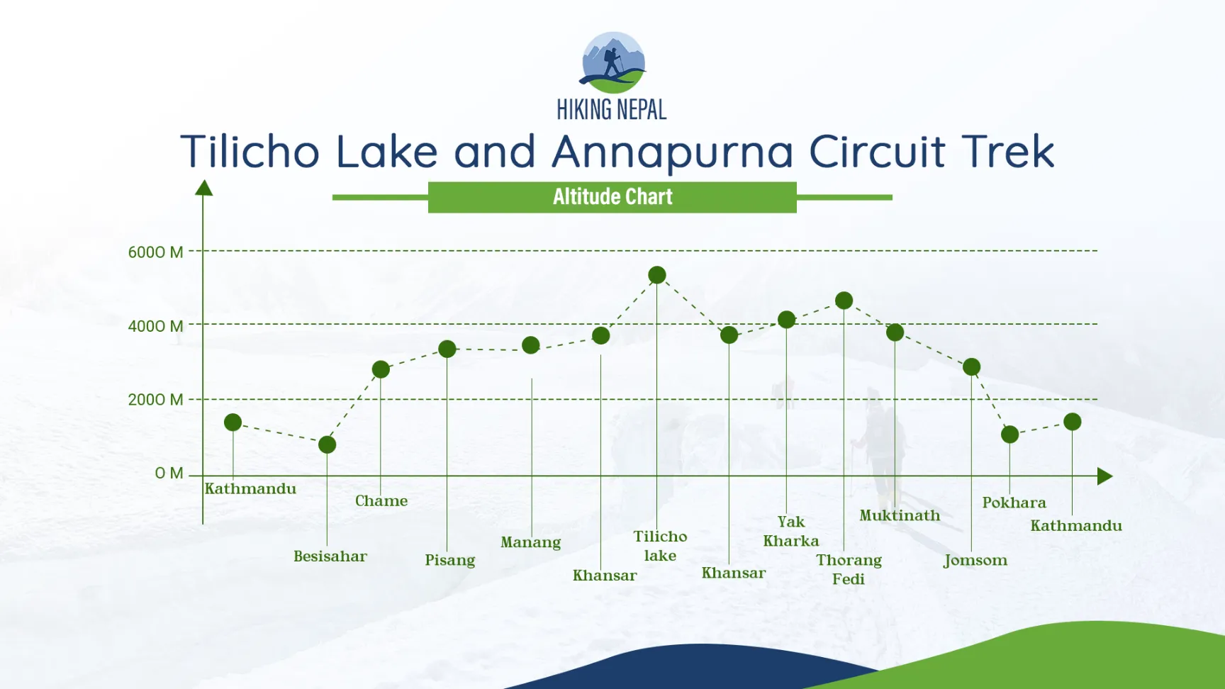
Day 01: Arrival day in Kathmandu transfer to Hotel (1350/4428 ft) (Meal: Dinner)
Day 02: Drive to Besisahar 6-7 hrs (760 m/ 2510 ft) bus (Meal: BLD)
Day 03: Jeep drive to Chame (2670 m/8810 ft)Drive: 7/8 hrs. (Meal: BLD)
Day 04: Trek from Chame to Pisang (3200 m/10524 ft) Trek: 5- 6 hours (Meal: BLD)
Day 05: Trek from Pisang to Manang, (3400 m/11152 ft) Trek: 5 to 6 hrs. (Meal: BLD)
Day 06: Rest day at Manang for acclimatization (3400 m/11152 ft) (Meal: BLD)
Day 07: Short Trek from Manang to Khansar Village (3734 m/12322 ft) Treks 2 to 3 hrs. (Meal: BLD)
Day 08: Excursion to Tilicho Lake, back to Tilicho Base Camp/Khangsar village ( 5200m/17056ft) Trek: 6 to 7 hrs. (Meal: BLD)
Day 09: Trek from Khansar Village to Yak Kharka ( 4010m/13153ft), Trek: 4-5 hrs. (Meal: BLD)
Day 10: Trek from Yak Kharka to Thorong Phedi (4,600m/15,092ft. Trek: 5-6 hrs. (Meal: BLD)
Day 11: Trek to Muktinath (3,800m, 12464ft) via Thorung La pass (5,416m, 17332ft) Trek: 7-8 hrs. (Meal: BLD)
Day 12: Trek from Muktinath to Jomsom (2720 m/ 8976 ft) Trek: 5-6 hrs. (Meal: BLD)
Day 13: Fly to Pokhara, transfer to Hotel ( 820 m/2705 ft) Flight: 20 minutes.
Day 14: Drive to Kathmandu (1350/4428 ft) (Meal: B/D)
Day 15: Departure from Kathmandu (1350/4428 ft) (Meal: Breakfast)
Why combine Tilicho Lake with the Annapurna Circuit?
Many trekkers complete the Annapurna Circuit without visiting Tilicho Lake. Fewer come specifically for the lake without continuing to Thorong La. Both decisions leave something significant behind.
The Annapurna Circuit alone is an outstanding trek. But the detour to Tilicho Lake adds three days of high-altitude walking through terrain that most trekkers on the main circuit never see. The trail to the lake branches off from Manang and passes through Khangsar, a quiet stone village that feels worlds apart from the teahouse crowds at the main circuit stops. The final approach to the lake traverses a narrow path along a moraine ridge with sheer drops below and the jagged profile of Tilicho Peak (7,134 metres) and Nilgiri North rising directly ahead. There is nothing quite like arriving at the lake after that final climb.
The Tilicho Lake excursion also extends your acclimatisation period before Thorong La. Trekkers who take the lake detour arrive at Thorong Phedi better adapted to altitude than those who rest only in Manang. The extra days at elevation are not wasted days; they are the days that make the pass crossing safer and more manageable.
Doing both within fifteen days is entirely feasible for trekkers with a reasonable level of fitness. The itinerary is structured to allow proper acclimatisation without rushing, and every key stage has been positioned to give the body time to adjust before the next significant altitude gain.
About Tilicho Lake
Tilicho Lake sits at an altitude of 4,919 metres (16,138 feet) within the Annapurna Conservation Area of the Manang District. It is one of the highest lakes in the world accessible to trekkers without technical climbing equipment, and for decades, it was described as the highest lake on earth. That claim now belongs to Kajin Sara Lake in the nearby Nar Phu region at 5,020 metres, but Tilicho holds a different record: it is the lake with the longest diameter at this altitude, measuring approximately four kilometres in length and 1.2 kilometres across, covering an area of roughly 4.8 square kilometres.
The lake is fed entirely by glacial meltwater from the surrounding peaks, primarily from Tilicho Peak itself. No rivers flow out. The water that enters the lake stays within it, held in place by natural moraine dams formed over thousands of years of glacial activity. The result is a body of water of extraordinary clarity, its surface shifting between deep turquoise and silver depending on the light and cloud conditions overhead.
No aquatic organisms have ever been recorded in the lake. The water temperature and extreme environmental conditions at this altitude prevent the establishment of any fish or larger life forms. In 2000, a Russian team conducted what became one of the highest-altitude scuba dives ever recorded in the lake. The depth of Tilicho has been estimated at approximately 85 metres, enough to submerge a twenty-storey building.
The lake was introduced to the wider world during the 1950 French Annapurna expedition led by Maurice Herzog, the first successful ascent of an eight-thousander. Local communities in the Manang valley had known of the lake for centuries. It holds significance in both Hindu and Buddhist traditions within the region.
Standing at the shoreline with Tilicho Peak, Nilgiri, and Muktinath Peak reflected in the water on a clear morning is among the most arresting visual experiences available anywhere in the Himalayas.
Trek difficulty
This trek is rated moderate to challenging. It is not a technical climb and requires no mountaineering skills or specialised equipment beyond standard trekking gear. The challenge comes from sustained altitude, daily walking distances, and the physical demands of the Thorong La Pass crossing day.
Daily effort
Average daily walking time on this itinerary is between five and seven hours. Most stages involve a combination of ascending and descending on Rocky Mountain trails. The drives from Kathmandu to Besisahar and from Besisahar to Chame are long but allow the body to begin adjusting to altitude passively.
The most demanding sections
Shree Kharka to Tilicho Lake (Day 8): The trail from Tilicho Base Camp to the lake is the most technically demanding section of the entire itinerary. The path traverses a narrow moraine ridge that is landslide-prone in places. The gradient is steep, and the altitude means that even short uphill sections require deliberate pacing. Allow six to seven hours for the full day, including the return to base camp.
Thorong Phedi to Muktinath via Thorong La Pass (Day 11): This is the longest and most physically demanding day of the trek. It begins before dawn, typically between 3:00 and 5:00 in the morning, and involves a steep five-hour ascent to the pass at 5,416 metres followed by a descent to Muktinath at 3,800 metres. Total walking time is seven to eight hours. The combination of cold, altitude, and duration makes this the day that requires the most mental and physical preparation.
Who is this trek suitable for?
This trek is suitable for trekkers who are physically active in daily life, can walk with a day pack for five to seven hours without significant difficulty, and are comfortable with high-altitude environments. Prior trekking experience is recommended but not mandatory if physical preparation has been thorough. Trekkers with previous high-altitude experience above 3,500 metres will find the acclimatisation process considerably easier.
This trek is not recommended for trekkers with serious heart or lung conditions, those who have experienced severe altitude sickness previously, or anyone who has been inactive in the months before the trip. If you are unsure whether this trek is appropriate for you, consult your doctor before booking and speak to our team.
Crossing Thorong La Pass
Thorong La Pass at 5,416 metres is the highest point on the Annapurna Circuit and the defining challenge of this itinerary. It connects the Manang valley on the eastern side with the Mustang plateau and Muktinath on the western side. The landscape on either side of the pass is completely different: the green, forested terrain of the Marsyangdi valley gives way to the arid, wind-swept plateau of Lower Mustang.
Why the early start is not optional
Every trekker attempting Thorong La must leave before dawn. The standard departure time from Thorong Phedi is between 3:00 and 4:00 in the morning. From High Camp, departures are typically between 4:00 and 5:00. This is not tradition or preference; it is safety.
Thorong La sits in a natural wind tunnel between Khatung Kang and Yakawa Kang peaks. By mid-morning, powerful afternoon winds funnel through the pass with regularity. After 10:00 in the morning, wind chill can drive temperatures down to minus 20 degrees Celsius or below. Trekkers who leave late find the crossing increasingly dangerous as the morning progresses. The aim is to reach the summit by 8:00 or 9:00, giving enough time to complete most of the descent to Muktinath before conditions deteriorate.
In autumn, the cold is more intense from the outset, and guides typically push for 3:00 departures. In spring, the winds are calmer but residual winter snow may still be present on the trail, making an early start equally important to keep the snow frozen and firm underfoot.
What the crossing feels like
The ascent from Thorong Phedi takes approximately four to five hours. The trail begins in darkness, headtorches lighting a narrow path through rocky terrain. The gradient is consistent and steep. At this altitude, even gentle inclines demand deliberate pacing; the temptation to push forward quickly should be resisted entirely.
As the sun rises over the eastern peaks, the mountains turn gold and pink. By the time most trekkers approach the summit, the light is extraordinary. A cluster of prayer flags marks the top of the pass. Trekkers stop, breathe, take photographs, and simply absorb where they are. The Tibetan plateau stretches to the north. The Annapurna massif dominates the southern skyline. The descent to Muktinath takes a further three to four hours.
When the pass is closed
Heavy snowfall can close Thorong La, particularly in late November through February and occasionally in early December. If the pass is reported closed on your crossing day, your guide will advise on whether to wait at High Camp for conditions to improve or to return to Manang. Do not attempt the crossing if your guide advises against it. The decision to turn back is always made in your interest.
Acclimatisation: why Manang matters
The rest day at Manang on Day 6 is one of the most important days of this trek, though it may not feel like it at the time. Manang sits at 3,400 metres, and the body needs time at this altitude before ascending further. The principle of high-altitude acclimatisation is consistent: climb high, sleep low. On rest days, a short hike to a higher elevation followed by a return to the village overnight is more effective than simply remaining at the same altitude.
What to do on your acclimatisation day in Manang
Hike to Ice Lake (4,600 metres): This is the most popular acclimatisation hike from Manang and the most effective. The lake sits in a bowl above the village with views of the Annapurna and Gangapurna ranges. The hike takes four to five hours return.
Visit Gangapurna Glacier: A shorter walk from the village to the glacial lake at the base of Gangapurna. Good for an easy morning if energy levels are low.
Attend the altitude awareness talk: The Himalayan Rescue Association clinic in Manang offers daily talks on altitude sickness, symptoms, and treatment. Attendance is strongly recommended for all trekkers, regardless of experience.
Explore Braga Gompa: One of the oldest Buddhist monasteries in the Annapurna region sits just below Manang at the village of Braga. The monastery contains centuries-old statues and thangkas and is well worth the short walk.
Best time for Tilicho Lake trek
This trek is offered in spring, autumn, and winter. Each season has distinct characteristics.
The months of April, May, October, and the first half of November offer the most reliable conditions for both the Tilicho Lake excursion and the Thorong La crossing.
Permits required for this trek in 2026
Two permits are required for this trek and both are included in your package price with Hiking Nepal.
Annapurna Conservation Area Project (ACAP) permit
The ACAP permit grants entry to the Annapurna Conservation Area, which covers the entire route of this trek. It is issued by the National Trust for Nature Conservation (NTNC). The permit must be carried at all times and presented at checkpoints along the route.
TIMS card (Trekkers Information Management System)
The TIMS card is a mandatory registration document for all trekkers in Nepal. The system was updated to e-TIMS in 2026, allowing pre-registration online before arrival in Nepal. Trekkers can now link their visa application submission ID to initiate the process from their home country, collecting the physical document in Kathmandu before the trek begins. Hiking Nepal handles the full TIMS application process on your behalf as part of your booking.
Mandatory guide requirement
As of 2023 and fully enforced from 2026, all foreign trekkers in Nepal's national parks and conservation areas must be accompanied by a licensed, government-registered guide. This regulation applies to all stages of this route. Solo trekking in conservation areas is not legally permitted, regardless of experience level. Hiking Nepal provides TAAN-certified, English-speaking guides for all departures. Your guide's licence details are registered with the relevant authorities before departure.
What to pack for this trek
Clothing and layers
- Base layer (thermal, moisture-wicking): at least two sets
- Mid layer (fleece or down jacket): essential from Manang onwards
- Outer shell (waterproof and windproof jacket and trousers): for Tilicho Lake day and Thorong La crossing
- Down jacket or very warm insulated jacket: required for Thorong La; temperatures at the pass regularly fall below minus 10 degrees Celsius before dawn
- Warm hat, balaclava, and liner gloves plus outer mitts
- Neck gaiter or buff
- Trekking trousers: at least two pairs
- Thermal leggings: for sleeping and Thorong La day
- Sun hat and sunglasses with UV protection: essential at altitude
Footwear
- Waterproof trekking boots with ankle support: broken in before the trek
- Camp shoes or sandals for teahouse evenings
- Wool or synthetic trekking socks: four to five pairs minimum
- Microspikes or crampons: recommended for late autumn or winter departures when ice is likely on Thorong La
- Gaiters: useful on the Tilicho Lake trail if snow is present
Equipment
- Sleeping bag rated to minus 10 degrees Celsius: Hiking Nepal provides a sleeping bag and down jacket on request if needed
- Trekking poles: strongly recommended for the Tilicho Lake moraine section and the long Thorong La descent
- Headtorch with spare batteries: essential for the pre-dawn Thorong La start
- Water bottles (two litres capacity) or hydration bladder
- Water purification tablets or a personal filter
- Sunscreen (SPF 50 minimum) and lip balm with SPF
- Personal first aid kit including blister plasters and altitude medication
- Small daypack (25 to 30 litres) for daily use alongside the porter duffle
Medication
Speak to your doctor before the trek about altitude medication. Acetazolamide (Diamox) is commonly prescribed to aid acclimatisation and reduce AMS risk. Ibuprofen is useful for headaches at altitude. Carry any prescription medications in sufficient quantity for the full trip duration plus a buffer. Do not rely on resupply in mountain villages.
Muktinath: what to expect after Thorong La
Arriving at Muktinath after crossing Thorong La is one of the emotional high points of this trek. The village sits at 3,800 metres in the Mustang plateau, and the descent from the pass brings a distinct physical relief as oxygen levels improve with every hundred metres of altitude lost.
Muktinath is one of the most sacred pilgrimage sites in the Himalayan region, revered equally by Hindus and Buddhists. The Muktinath Temple complex contains 108 water spouts arranged in a semicircle, each releasing glacial spring water that pilgrims consider holy. Within the same complex, a natural flame fed by underground gas burns continuously at the surface of a stream, a phenomenon that both traditions regard as sacred. The temple draws pilgrims from Nepal, Tibet, and India throughout the year.
Most trekkers arrive at Muktinath in the early to mid-afternoon after the Thorong La crossing. A visit to the temple complex before resting for the night is worth the effort despite the fatigue of the day.
Jomsom and the flight to Pokhara
The final trekking day descends from Muktinath through the Kali Gandaki valley to Jomsom at 2,720 metres. The Kali Gandaki gorge is frequently cited as the deepest river gorge on earth; the river runs between Dhaulagiri to the west and Annapurna to the east, both of which exceed 8,000 metres. The descent follows the river downstream, passing through Kagbeni, the traditional gateway to Upper Mustang, before the afternoon winds of the Kali Gandaki valley pick up and accompany the final stretch into Jomsom.
Jomsom is the administrative centre of Mustang District. It has a small airport with daily morning flights to Pokhara that take approximately twenty minutes. These flights operate in the morning before the Kali Gandaki winds strengthen. Afternoon flights are rare. Your guide will confirm flight times and arrangements the evening before departure.
It is worth noting that Jomsom flights are cancelled more frequently than other short-haul mountain routes in Nepal due to wind conditions. If your flight is cancelled, the alternative is a full-day drive via Beni to Pokhara, which takes approximately six to eight hours depending on road conditions. Hiking Nepal monitors flight status and will make alternative arrangements immediately if needed.
Costs, inclusions, and exclusions:
What is included
🟢Airport transfer by Hiking Nepal office representative in a private vehicle
🟢Farewell Dinner at finest restaurant in Thamel Kathmandu
🟢Kathmandu to Besisahar transfer in a sharing vehicle- upgrade to private vehicle is also available
🟢Besisahar to Chame drive in a sharing vehicle
🟢2 Nights’ accommodation at Tourist Standard 3 Star Hotel in Kathmandu with breakfast on twin sharing basis
🟢11 Nights’ accommodation at well and comfortable Mountain Lodge available en-route during trek (Few nights’ at during trek with attached bathroom/toilets)
🟢1 Night accommodation at 3 star Hotel in Pokhara with breakfast on twin sharing basis
🟢Full Board Meal during trek (Breakfast, Lunch, Dinner, tea & coffee, seasonal fruits, chocolate/s & biscuits)
🟢English speaking, First Aid and Eco-trained local trekking guide, Assistance guide as per the group size, porters (2:1), all the expenses for guide and porters along with Insurance
🟢Domestic Airfare and Tax for the sector Jomsom/Pokhara
🟢Pokhara to Kathmandu transfer in a Tourist Bus- Option for private vehicle or flight is available
🟢Annapurna Conservation Area Project (ACAP) fee
🟢Trekkers Information Management System (TIMS) card fees
🟢Exclusive medical kit bag, Duffle Bag, Trekking T-shirt, Adventure Certificate
🟢Sleeping Bag and Down Jacket during Trek if required
🟢All Government and local taxes as applicable
What is not included
🔴Nepal Visa (Cost US$30 for 15 Days & US$50 for 30 Days)
🔴Lunch & evening meals while in Kathmandu and Pokhara (Except welcome/farewell dinner)
🔴Travel Insurance
🔴Cost of personal nature expenses, Beverages (Mineral water or coca cola), cost of extra meals, snacks, phones bills, Internet, WiFi, laundry etc.
🔴Cost incurred during emergency, evacuations
🔴Tips for Guide/porters/driver
🔴 Anything other than not mentioned in “Service Includes”
Map
Altitude Chart
DETAILED ITINERARY
Day 1 Arrive in Kathmandu
Altitude: 1,350 m (4,429 ft) Meals: Dinner Accommodation: 3-star hotel, Kathmandu
Your trek begins before you lace your boots. On arrival at Tribhuvan International Airport in Kathmandu, a Hiking Nepal representative will be waiting to escort you to your hotel in a private vehicle. Once you have checked in and had time to rest and freshen up, your guide will come to your room to brief you on the itinerary, answer any questions about the days ahead, and run through kit and equipment.
In the evening, Hiking Nepal hosts a welcome dinner at a restaurant in Thamel, introducing you to Nepali cuisine and giving you the chance to meet your guide properly before the trek begins. Dishes such as dal bhat, momo dumplings, and Newari specialities are common at this dinner. It is a good opportunity to discuss your fitness level, any concerns you have, and what to expect on the road to Besisahar the following morning.
Tip: If you have arrived on a long-haul flight, drink plenty of water on your first evening in Kathmandu. The city sits at 1,350 m, which is enough altitude to cause mild dehydration after a long flight.
Day 2 Drive from Kathmandu to Besisahar
Altitude: 760 m (2,493 ft) Drive: 6 to 8 hours (jeep or bus) Meals: Breakfast, lunch and dinner Accommodation: Local teahouse, Besisahar
After breakfast at the hotel, your guide meets you in the lobby and you depart Kathmandu by private jeep or tourist bus depending on your group size and preference. The route heads west out of the city along the Prithvi Highway, following the Trisuli River before turning north along the Marsyangdi River valley. The drive is scenic throughout: the road passes through scattered Gurung and Magar villages, over suspension bridges, and alongside rice terraces that give way to forested hillsides as you gain elevation.
Besisahar is the official trailhead for the Annapurna Circuit and the administrative headquarters of the Lamjung District. The town has a good range of teahouses, gear shops, and pharmacies. This is your last opportunity to stock up on any equipment or medication you may have forgotten before the trail becomes remote. Your guide will ensure your ACAP permit and TIMS card are in order here if not already completed in Kathmandu.
Altitude note: Besisahar sits at 760 m, well below Kathmandu. The drive itself does not take you to altitude; Day 3 begins the gradual ascent. Use Day 2 as a restful transition day.
Day 3 Drive from Besisahar to Chame
Altitude: 2,670 m (8,760 ft) Drive: 6 to 8 hours by jeep or local bus Meals: Breakfast, lunch, and dinner Accommodation: Local teahouse, Chame
The drive from Besisahar to Chame follows an increasingly rough mountain road along the Marsyangdi River gorge into the heart of the Annapurna Conservation Area. The road climbs steadily through dense subtropical forest, past waterfalls, and through villages where the architecture begins to shift from the lower-hill Nepali style to the heavier stone construction typical of mountain communities.
Chame is the district headquarters of Manang and the first significant settlement on the upper circuit. It sits at 2,670 m with a backdrop of Lamjung Himal and Annapurna II visible on clear mornings. The town has a post office, small shops, internet access (intermittent), and a good selection of teahouses. It also has the last reliable ATM before the trail climbs higher; withdraw cash here if needed.
The drive from Besisahar to Chame is often bumpy and can be slow on sections of unpaved road. It is not uncommon for the journey to take longer than expected after rain. Use the driving time to rest, look out of the window, and let the altitude gain happen gradually without physical exertion. By the time you arrive in Chame, your body has already begun adjusting to the elevation.
Acclimatisation note: The jump from 760 m to 2,670 m in a single day is substantial. Some trekkers experience a mild headache on arrival in Chame. Drink water consistently throughout the drive and avoid alcohol on this evening. If the headache persists, take ibuprofen and rest; do not ascend further until symptoms have cleared.
Day 4 Trek from Chame to Pisang
Altitude: 3,200 m (10,499 ft) Trek time: 5 to 6 hours Distance: approximately 17 km Meals: Breakfast, lunch and dinner Accommodation: Local teahouse, Pisang
Today is your first full trekking day and one of the most visually dramatic stages of the entire itinerary. The trail leaves Chame on a stone path that climbs steeply through dense pine and fir forest before narrowing into a gorge where the Marsyangdi River thunders below. You cross the river twice on suspension bridges at approximately 2,910 m and 3,040 m, both crossings offering views straight down into the raging torrent below and straight up at the sheer rock walls of the gorge.
After the second bridge, the landscape opens suddenly. The curved rock face of Paungda Danda appears directly ahead, its smooth granite wall rising 1,500 metres from the valley floor in a single sweep. This is one of the most photographed natural features on the entire circuit. The trail continues north-east through increasingly arid terrain as the valley widens and the first signs of the Manang rain shadow begin to appear. Scattered settlements of stone-walled houses with flat roofs replace the tiled rooftops of the lower valley.
Pisang consists of two parts: Lower Pisang at around 3,200 m and Upper Pisang at approximately 3,300 m. Upper Pisang sits on a ridge with a small white gompa (Buddhist monastery) and offers a wider panorama of the Annapurna range. If you have the energy, the short climb to Upper Pisang for sunset views is well worth the extra thirty minutes. Most teahouses are in Lower Pisang.
What to look out for today: The shift in vegetation from subtropical forest to high-altitude pine and then to semi-arid scrubland happens quickly on this stage. The rain shadow effect of the Annapurna massif becomes visually apparent by the time you reach the approaches to Pisang.
Day 5 Trek from Pisang to Manang
Altitude: 3,519 m (11,545 ft) Trek time: 5 to 6 hours Distance: approximately 22 km (northern high route) or 16 km (southern low route) Meals: Breakfast, lunch and dinner Accommodation: Teahouse, Manang
Today offers a genuine choice of routes, and it is worth discussing both options with your guide the evening before. The southern low route follows the valley floor along the river. It is shorter and less demanding. The northern high route climbs above Pisang to Ghyaru (3,670 m) and Ngawal before descending to Manang. The high route takes one to two hours longer but offers the best views of the Annapurna range available from any point on the circuit.
The high route from Ghyaru opens onto a panorama that stops most trekkers in their tracks: Annapurna II (7,937 m), Annapurna III (7,555 m), Annapurna IV (7,525 m), Gangapurna (7,455 m), and the distinctive silhouette of Pisang Peak (6,091 m) are all visible simultaneously. The village of Ghyaru itself is one of the most authentic settlements on the circuit, with white-washed stone houses, carved wooden windows, and mani walls running along the path.
After Ghyaru, the trail descends through Ngawal before crossing the valley to join the main circuit at Manang. The village of Braga (3,475 m) is passed along the way. Braga Gompa, one of the oldest Buddhist monasteries in the Annapurna region, sits above the village and contains centuries-old thangka paintings, statues, and manuscript collections. If time allows, a short visit is worthwhile.
Manang is the largest settlement on the upper circuit and the last significant town before the high passes. It has a proper high street with teahouses, gear shops, bakeries, a cinema (showing trekking films in the evenings), and the Himalayan Rescue Association clinic, which offers twice-daily talks on altitude sickness. Accommodation is more comfortable here than anywhere on the upper circuit.
Recommendation: Take the northern high route if your fitness and acclimatisation are on track. The views from Ghyaru are among the finest of the entire trek and the additional altitude gained helps your body prepare for the days ahead. Confirm this with your guide based on how you felt on Day 4.
Day 6 Acclimatisation day in Manang
Altitude: 3,519 m (11,545 ft) Activity: Rest day with optional acclimatisation hikes Meals: Breakfast, lunch and dinner Accommodation: Teahouse, Manang
The rest day in Manang is not a day off. It is one of the most important days of the entire trek. The body needs time at this altitude before ascending further, and the activities you choose today will directly affect how you perform on the Tilicho Lake excursion and the Thorong La crossing later in the itinerary.
The principle of high-altitude acclimatisation is consistent: climb high, sleep low. On a rest day, a hike to a higher elevation followed by a return to Manang for the night is more effective than simply staying at the same altitude. The two most popular options from Manang are described below.
Ice Lake (4,600 m): The most effective acclimatisation hike from Manang. The trail climbs steeply above the village through juniper scrub and moraine terrain to a small glacial lake sitting in a bowl of peaks. The views of the Annapurna range and Gangapurna from the lake are outstanding. The round trip takes four to five hours and gains nearly 1,100 m of altitude. This is a real test of your current fitness and acclimatisation; your guide will use how you perform here to assess readiness for the days ahead.
Gangapurna Glacier viewpoint (3,700 m): A shorter and less demanding walk to the glacial lake at the base of Gangapurna. The walk takes one to two hours return and is a good option if you are feeling the altitude or want to conserve energy.
In the afternoon, attend the Himalayan Rescue Association altitude sickness awareness talk at the clinic in the centre of Manang. The talk covers the symptoms of Acute Mountain Sickness (AMS), High Altitude Cerebral Oedema (HACE), and High Altitude Pulmonary Oedema (HAPE), and explains precisely what to do if you or a fellow trekker develops any of these conditions on the trail. Attendance takes one hour and is strongly recommended for every trekker regardless of prior experience.
Manang is also worth exploring on foot. The main street has a bakery producing fresh bread and apple pie using locally grown apples from the Kali Gandaki valley. The cave dwellings carved into the cliff above the village are visible from the street and can be reached on a short scramble above the houses.
Medication note: If you are taking Acetazolamide (Diamox) to aid acclimatisation, today is a good day to assess whether it is working as expected. Common side effects include increased urination and tingling in the fingers. Speak to your guide if you have any concerns about your symptoms.
Day 7 Trek from Manang to Khangsar village
Altitude: 3,734 m (12,251 ft) Trek time: 2 to 3 hours Meals: Breakfast, lunch and dinner Accommodation: Teahouse, Khangsar
Today is a deliberately short stage designed to gain altitude gradually before the Tilicho Lake excursion the following morning. The trail leaves Manang on a clear path heading west, cutting through a steep-sided gorge before climbing to Khangsar. As the gorge narrows, the profile of Tilicho Peak (7,134 m) appears directly ahead, framed by the walls of the valley. It is the first clear view of the mountain that gives the lake its name, and it is striking.
The path passes through small settlements, crosses a stone wall that marks an ancient boundary of the upper grazing lands, and follows the Khangsar Khola (river) before reaching the village. Khangsar is a compact, traditional Tibetan-influenced settlement with flat-roofed stone houses, a small monastery, and a population that has lived at this altitude for generations. It sees far fewer trekkers than the main circuit and retains an atmosphere that has largely disappeared from the busier stops further down the valley.
The short walking day leaves the afternoon free to rest, adjust to the altitude gain, and prepare for tomorrow. Eat a full dinner, drink at least three litres of water throughout the day, and go to bed early. The Tilicho Lake excursion begins at first light.
Preparation for Day 8: Pack your daypack the night before. You will need warm layers (the lake sits at 4,919 m and temperatures at the base camp approach are cold even in summer), snacks for the trail, two litres of water, sunscreen, sunglasses, and your headtorch. Your main duffle stays at the teahouse in Khangsar.
Day 8 Excursion to Tilicho Lake and return to Khangsar
Altitude: Tilicho Lake: 4,919 m (16,138 ft) Trek time: 6 to 7 hours total Meals: Breakfast, lunch and dinner Accommodation: Teahouse, Khangsar or Tilicho Base Camp
This is the highlight of the entire itinerary and one of the most visually extraordinary days available on any trek in Nepal. Set an early alarm; departures from Khangsar are typically at dawn or just before to allow enough time for the ascent, time at the lake, and the return before darkness.
The trail leaves Khangsar on a clear path that climbs gradually through grassy alpine terrain before the gradient increases sharply. The path then traverses a narrow moraine ridge. This section demands full concentration: the path is exposed on the downhill side, the rock is loose in places, and the combination of altitude and gradient makes it physically demanding. Take it steadily. Your guide will set the pace.
From the moraine, the trail approaches Tilicho Base Camp at approximately 4,150 m. This is a rest stop with a basic teahouse where you can take hot tea and something to eat before the final push to the lake. Above the base camp, the trail climbs steeply onto a second moraine through raw, high-altitude terrain that feels genuinely remote. The peaks surrounding you here, Tilicho Peak directly above, Nilgiri North to the south-west, and Muktinath Peak visible to the north, form a complete amphitheatre of rock and ice.
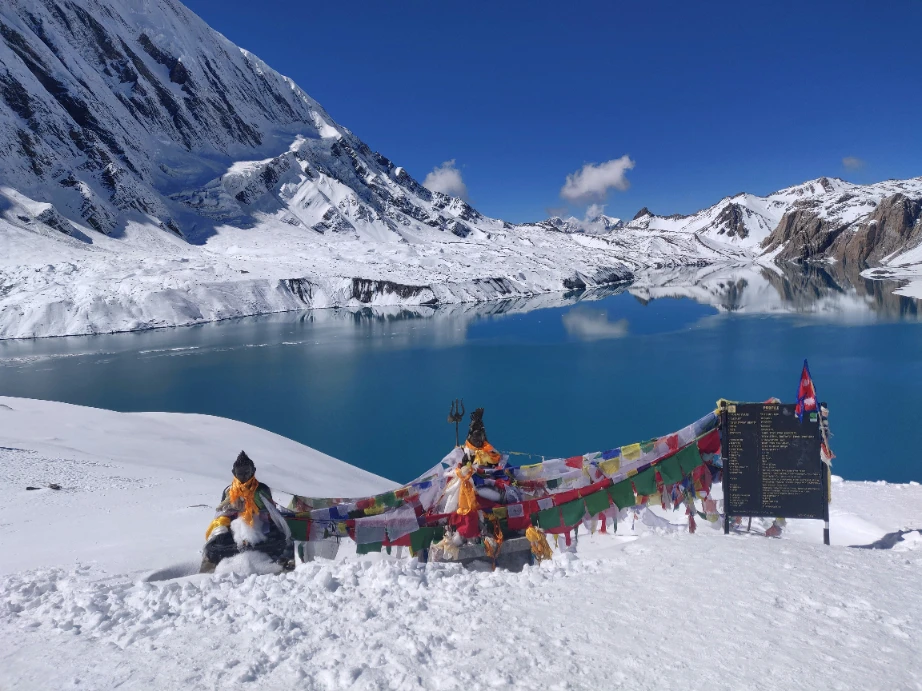
Tilicho Lake appears suddenly as you crest the final ridge. The lake sits in a broad, flat-floored bowl at 4,919 m, its surface a deep turquoise that shifts to silver as cloud passes overhead. The diameter of the lake is approximately four kilometres, making it the largest body of water at this altitude accessible to trekkers in Nepal. No rivers flow into or out of the lake; it is fed entirely by glacial meltwater from the surrounding peaks and held within its basin by natural moraine dams. No aquatic life has ever been recorded here.
Spend time at the lake. There is no rush to descend immediately. Sit at the shoreline, take photographs, and absorb where you are. The silence at this altitude is profound. On a clear morning, the reflection of the peaks in the still water of the lake is one of the most beautiful sights in the Himalayas.
The return to Khangsar follows the same route in reverse. The descent from the lake to the base camp is steep in places; use trekking poles if you have them and take the descent slowly to protect your knees. Allow three to four hours for the full return.
Important safety note: The path between Khangsar and Tilicho Base Camp traverses a landslide-prone slope. Follow your guide's instructions carefully on this section. Do not leave the marked path and do not rush. The exposure is manageable with proper attention but carelessness here has caused accidents. If your guide advises turning back due to conditions, the decision is made entirely in your interest.
Day 9 Trek from Khangsar to Yak Kharka
Altitude: 4,010 m (13,156 ft) Trek time: 4 to 5 hours Meals: Breakfast, lunch and dinner Accommodation: Teahouse, Yak Kharka
After the physical effort of the Tilicho Lake excursion, today is a recovery and transition day. The trail descends from Khangsar, passes the ruins of the old Khangsar settlement, and crosses the valley on a wooden suspension bridge before climbing gently to Yak Kharka at 4,010 m.
Yak Kharka translates literally as yak pasture. The settlement is small, consisting of a handful of teahouses set on an open plateau above the valley. Yaks are often visible grazing on the surrounding hillsides, particularly in the late afternoon when they are brought down from the higher pastures. Looking south from Yak Kharka, the full southern face of Annapurna III (7,555 m) is directly visible across the valley.
The walking today is relatively straightforward compared to yesterday. The trail gains altitude gradually rather than steeply, which is intentional. By the time you reach Yak Kharka, your body has spent several days above 3,500 m and is adjusting well. The modest altitude gain today continues that adjustment without overstressing the system before the bigger climbs ahead.
Yak Kharka has limited accommodation options, so your guide will book ahead. The teahouses are basic but comfortable enough for one night. The sky at Yak Kharka on a clear night is extraordinary; the combination of altitude and the absence of light pollution makes stargazing here one of the genuinely memorable incidental experiences of the trek.
Eating and drinking: At this altitude, appetite often diminishes. Even if you do not feel hungry, make yourself eat a proper dinner. The Thorong La crossing is two days away and your energy reserves need to be full. Carbohydrate-rich foods such as dal bhat, pasta, and rice are the best choice at altitude.
Day 10 Trek from Yak Kharka to Thorong Phedi
Altitude: 4,450 m (14,600 ft) Trek time: 3 to 4 hours Meals: Breakfast, lunch and dinner Accommodation: Teahouse, Thorong Phedi or High Camp (4,850 m)
Today's stage is short by distance but significant in purpose. The trail climbs from Yak Kharka along the northern bank of the river, crosses a suspension bridge at Ledar village, and then ascends through increasingly exposed terrain to Thorong Phedi. The path passes between towering cliff faces with views of Gundang, Thorong Peak, Syangang, and Khatungkang throughout the upper section.
Thorong Phedi (the name means foot of the pass in Nepali) is the base camp for the Thorong La crossing. It sits at 4,450 m and consists of a cluster of teahouses that exist purely to serve trekkers preparing for the following day. The atmosphere here is different from anywhere else on the circuit: quieter, more focused, and charged with anticipation. Most trekkers spend the afternoon resting, hydrating, and preparing their kit for the early start.
Some trekkers choose to continue an additional 400 m of altitude to High Camp at 4,850 m, which reduces the total ascent on pass day. Whether to stay at Phedi or continue to High Camp is a decision to make with your guide based on how you are feeling and how the weather looks for the following morning. If you sleep at High Camp, your departure for the pass will be slightly later (around 4:00 to 5:00 in the morning) than from Phedi (around 3:00 to 4:00).
Go to bed as early as possible tonight regardless of where you sleep. Set your alarm for the planned departure time, have your kit packed and ready before you sleep, and do not be tempted to stay up late. Tomorrow is the hardest day of the trek.
Final preparation checklist for Thorong La day: Down jacket and thermal layers ready at the top of your bag. Headtorch with fresh batteries in your jacket pocket. Two litres of water (water may freeze at High Camp before dawn). High-calorie snacks. Sunscreen and sunglasses. Trekking poles adjusted to the correct height. Any medication your doctor has prescribed for altitude.
Day 11 Cross Thorong La Pass to Muktinath
Altitude: Thorong La Pass: 5,416 m (17,769 ft) | Muktinath: 3,800 m (12,467 ft) Trek time: 7 to 9 hours total Ascent: Approximately 1,000 m from Thorong Phedi Descent: Approximately 1,600 m to Muktinath Meals: Breakfast, lunch and dinner Accommodation: Teahouse or guesthouse, Muktinath
This is the most demanding day of the trek and the one that defines the entire Annapurna Circuit experience. The Thorong La Pass at 5,416 m is the highest point on the classic circuit and among the highest trekking passes in the world that can be crossed without technical equipment. The crossing is not technically difficult, but it is long, cold, and physically exhausting in ways that altitude makes harder to predict in advance.
Why you must start before dawn
Thorong La sits in a natural wind funnel between Khatung Kang and Yakawa Kang peaks. Every day of the year, without exception, strong winds develop on the pass by mid-morning. After 10:00 in the morning, wind chill at the summit can push the effective temperature to minus 20 degrees Celsius or below. The unwritten rule on Thorong La is clear: be at the summit by 8:00 or 9:00 in the morning at the latest.
Departures from Thorong Phedi are typically between 3:00 and 4:00 in the morning. From High Camp, between 4:00 and 5:00. Your guide will determine the exact time based on season, weather conditions, and trail reports. Do not argue for a later start. The early departure is not a cultural quirk; it is the single most important safety decision of the day.
The ascent
The trail from Phedi climbs immediately and steeply into darkness. Your headtorch lights a narrow cone ahead. The path is well-worn and well-marked but the gradient is relentless for the first two hours. The altitude makes every step feel heavier than it should. Your breathing will be laboured from the outset; this is normal. The technique that works best at this altitude is a slow, consistent pace with short rests every thirty to forty minutes rather than pushing hard and stopping frequently for long periods.
As you gain altitude, the first light of dawn begins to grey the sky above the eastern ridge. By the time the sun rises properly, most trekkers are within one to two hours of the summit. The landscape at this point is purely high-altitude: raw rock, patchy snow, and the thin, clean air of the upper Himalayas. There is very little vegetation above 5,000 m.
The summit
The summit of Thorong La is marked by a cluster of prayer flags strung between cairns, billowing in the wind that is already beginning to build even in the early morning. The views from the top are extraordinary in all directions. The Annapurna massif fills the southern horizon. To the north, the trans-Himalayan plateau of Mustang stretches towards Tibet. Looking east, the valley you have spent the past ten days walking up is visible far below.
Most trekkers spend fifteen to twenty minutes at the summit. Take photographs, catch your breath, and appreciate the moment. Then begin the descent. The summit is not the place to linger; the winds build quickly and the long descent to Muktinath still lies ahead.
The descent to Muktinath
The descent from Thorong La to Muktinath is a consistent downhill of approximately 1,600 m over three to four hours. The upper section of the path is steep and rocky; trekking poles are valuable here for protecting your knees on the uneven surface. The gradient eases as you approach the Mustang plateau and the landscape transforms dramatically from high-altitude rock and ice into the dry, ochre-coloured terrain of the rain shadow region beyond the pass.
With every hundred metres of altitude lost, the air becomes richer and breathing easier. By the time Muktinath comes into view, most trekkers feel a profound physical relief that is as much psychological as physiological. You have crossed Thorong La.
Muktinath
Muktinath is one of the most sacred pilgrimage sites in the entire Himalayan region, revered equally by Hindus and Buddhists. The temple complex sits at 3,800 m and draws pilgrims from Nepal, Tibet, and India throughout the year. The main temple complex contains 108 stone water spouts arranged in a semicircle, each releasing glacially fed spring water that pilgrims consider holy. Adjacent to the water spouts, a natural flame fed by underground gas burns continuously at the surface of a stream, a phenomenon that both traditions regard as sacred and that has been burning for as long as local records exist.
Most trekkers arrive at Muktinath in the early to mid afternoon. Despite the fatigue of the day, a visit to the temple complex before resting is worth the effort. The contrast between the raw physical effort of the pass crossing and the quiet, incense-scented calm of the temple precinct is one of the most striking transitions of the entire trek.
After crossing the pass: Eat a proper meal as soon as you arrive in Muktinath even if your appetite has disappeared, which is common after a major altitude effort. Drink water consistently. The descent will have dehydrated you. Avoid alcohol on this evening.
Day 12 Trek from Muktinath to Jomsom
Altitude: 2,720 m (8,924 ft) Trek time: 5 to 6 hours Meals: Breakfast, lunch and dinner Accommodation: Teahouse or hotel, Jomsom
The descent from Muktinath to Jomsom follows the Kali Gandaki River valley downstream through some of the most geologically remarkable landscape on the Annapurna Circuit. The Kali Gandaki gorge is frequently cited as the deepest river gorge on earth; the river runs between Dhaulagiri (8,167 m) to the west and the Annapurna range to the east, both of which rise more than eight thousand metres above the riverbed at their summits.
The trail passes through Kagbeni, the traditional gateway to Upper Mustang, where whitewashed buildings and a medieval-looking fortress tower over the confluence of the Kali Gandaki and Jhong Khola rivers. Kagbeni is the last point where trekkers without a special restricted area permit can enter Upper Mustang; the trail north of the village requires additional documentation. Many trekkers stop here for lunch.
Below Kagbeni, the wind picks up significantly. The Kali Gandaki valley acts as a natural wind channel between the high Himalayan ranges, and the afternoon thermals that flow up the valley from the south are often strong enough to make forward progress genuinely difficult. The wind typically strengthens between noon and 2:00 in the afternoon. It is worth moving at pace through this section or, if you have reached Jomsom by midday, stopping rather than continuing into the wind unnecessarily.
Jomsom is the administrative centre of Mustang District and the terminus of this trekking stage. It is a substantial town with a proper high street, hotels with attached bathrooms, a hospital, and an airport. The town is divided by the Kali Gandaki River: the older, more traditional side to the east and the newer tourist-facing area to the west. The apple orchards visible from the town produce the fruit used in the locally distilled apple brandy and cider that Jomsom is famous for throughout Nepal.
Flight confirmation: Your guide will confirm your Jomsom to Pokhara flight for the following morning on arrival in Jomsom. Jomsom flights operate exclusively in the morning before the Kali Gandaki winds strengthen. If your flight is cancelled due to wind or weather, Hiking Nepal will make alternative arrangements. The overland route to Pokhara via Beni takes six to eight hours by jeep.
Day 13 Fly from Jomsom to Pokhara
Altitude: Pokhara: 820 m (2,690 ft) Flight: Approximately 20 minutes Accommodation: 3-star hotel, Pokhara
The morning flight from Jomsom to Pokhara is one of Nepal's most spectacular short-haul routes. The small turboprop aircraft climbs out of the Kali Gandaki valley and banks south over the Mustang plateau before crossing the Himalayas at a pass that brings the full Annapurna and Dhaulagiri ranges into view through the aircraft windows. The flight takes approximately twenty minutes. Keep your camera or phone ready from the moment you board.
Flights from Jomsom are always scheduled for the morning. The landing strip is short and the approach demanding; pilots here are among the most experienced mountain aviation specialists in the world. Delays and cancellations are more common at Jomsom than at other Nepali airports due to wind conditions. If your flight is cancelled, do not be concerned; Hiking Nepal monitors all flights and will move you to the next available departure or arrange road transport to Pokhara if the day's flights are all cancelled.
Pokhara is Nepal's second-largest city and the trekking hub of the Annapurna region. The city sits on the northern shore of Phewa Lake with the full Annapurna range visible on clear days from the lakeside. After fifteen days of teahouse accommodation, the 3-star hotel in Pokhara will feel genuinely luxurious. Use the afternoon to rest, have a hot shower, do your laundry, and eat whatever you have been craving for the past two weeks. The Lakeside area of Pokhara has a wide range of restaurants serving everything from Nepali thali to wood-fired pizza.
If you have a free afternoon in Pokhara and the energy for it, the short boat ride across Phewa Lake to the Barahi Temple on its island is a pleasant way to spend an hour. The views of Machhapuchhre (Fishtail Mountain) at 6,993 m from the lake are among the most photographed in Nepal.
Day 14 Drive from Pokhara to Kathmandu
Altitude: Kathmandu: 1,350 m (4,429 ft) Drive: 5 to 7 hours by tourist bus or private vehicle Meals: Breakfast and dinner Accommodation: 3-star hotel, Kathmandu
The drive from Pokhara to Kathmandu follows the Prithvi Highway eastward along a route that traverses the middle hills of Nepal. The first section of the drive follows the Seti River before joining the Marsyangdi River valley highway that you first drove along on Day 2. The road then follows the Trisuli River through a narrow gorge before the final climb over a ridge and the long descent into the Kathmandu Valley.
The journey takes five to seven hours depending on traffic, which can be significant approaching Kathmandu. Roadside restaurants along the Trisuli gorge are popular stopping points for fish, which is freshly caught from the river and fried to order. This is considered something of a tradition on the Pokhara to Kathmandu drive and is worth experiencing if you are hungry.
On arrival in Kathmandu, you are transferred to your hotel in the city. In the evening, Hiking Nepal hosts a farewell dinner at a restaurant in Thamel, where your guide and other team members join you to celebrate the completion of the trek. This is the appropriate moment to tip your guide, porter, and any other staff who have contributed to your experience. Your guide will have looked after you throughout the trek and will appreciate a genuine acknowledgement.
Tipping guideline: Tipping is not compulsory but is standard practice in Nepal's trekking industry. A widely accepted guideline is USD 10 to 15 per trekker per day for your guide and USD 7 to 10 per trekker per day for your porter. Tips can be given individually or pooled and presented at the farewell dinner.
Day 15 Depart Kathmandu
Altitude: 1,350 m (4,429 ft) Meals: Breakfast
Your trek ends this morning. A Hiking Nepal representative will collect you from your hotel three hours before your scheduled departure time and escort you to Tribhuvan International Airport in a private vehicle. The drive from central Kathmandu to the airport takes between twenty minutes and one hour depending on traffic.
If your flight departs in the afternoon or evening and you have time to spare on your final morning, Kathmandu offers a great deal within easy reach of the Thamel area. The stupa at Boudhanath, the largest in Nepal, is a twenty-minute taxi ride from the tourist district and one of the most important Buddhist pilgrimage sites in Asia. Pashupatinath Temple on the banks of the Bagmati River is Nepal's most sacred Hindu site and is worth visiting even briefly. Both are accessible in a half-day if your flight permits.
From everyone at Hiking Nepal, thank you for trekking with us. The Tilicho Lake and Annapurna Circuit Trek is one of the most complete mountain experiences available anywhere in the world, and it has been our privilege to share it with you. We hope to see you on the trail again.
DEPARTURE DATES
| START DATE | END DATE | STATUS | PRICES |
|---|---|---|---|
| No departures found for October | |||
FAQ
REVIEWS
RELATED TRIPS

Short Annapurna Base Camp Trek
A short trek to Annapurna Base Camp is best way to reach base of Mt. Annapurna & Mt. Macchapuchr...
More Details
Dhampus Peak Climbing
An extraordinary way to begin the climbing journeys to the summits of Himalayan peaks – Dhampus Peak...
More Details
| 1 person | 2-7 person | 8+ person |
|---|---|---|
|
$ 1,590
Partial Pay
|
$
1,499
/ per
Partial Pay
|
$
1,199
/ per
Partial Pay
|




- Speak to one of our travel consultants
- Call Us (24/7) : +977 9802342080
-
 WhatsApp (24/7) : +977-9802342080