(This is an article written by our lovely guest, Nora Olsen, who did the Manaslu Circuit with us in 2026. This is not a paid post or writing for the sake of writing; we got this on our email from Nora, who wanted us to publish the whole experience, which we made into our content structure without promoting ourselves where she hasn’t done so. The article and the writings remain true to the source. Thank you, Nora, for these lovely words. )
I had done the Everest Base Camp in 2019 and the Annapurna Circuit the following year with two different agencies in Nepal. Both were extraordinary. Both were also, by the time I completed them, busy in a way I had not fully anticipated. The tea houses at Namche Bazaar in October felt like a hostel in Barcelona during festival season. The trail from Lukla to Phakding was a moving queue of trekkers, porters, and heavily laden yaks. None of this diminished the mountains, but it changed the experience around them in ways that took time to process afterwards.
When I started planning for 2026, I wanted something different. Not easier, not necessarily harder, but less visited. A circuit with genuine cultural depth, proper high-altitude challenge, and trails where I might walk for an hour without passing another group. A colleague who had been trekking in Nepal for fifteen years said two words: Manaslu Circuit.
I contacted Hiking Nepal in January. By April, I was standing at 5,160 metres on Larkya La Pass watching the sun come up over Himlung Himal with ice crystals forming on my jacket and my guide Padam standing three metres ahead of me, completely composed, asking if I wanted to take five minutes. This is the account of the fourteen days between those two moments.
Why I Chose the Manaslu Circuit
The Manaslu Circuit circumnavigates Mount Manaslu, the eighth-highest mountain in the world at 8,163 metres, in the Gorkha district of northern Nepal. The route covers approximately 177 kilometres over fourteen days, crosses the Larkya La Pass at 5,160 metres, and passes through Gurung and Tibetan Buddhist communities that have had significantly less contact with international trekking tourism than the villages on the Everest or Annapurna routes.
It is classified as a restricted trekking area, which means a special permit is required in addition to the standard TIMS card and ACAP permit, and the permit mandates that trekkers travel with a licensed guide through a registered agency. The restriction keeps independent walk-in tourism off the trail and is, in practice, the main reason the circuit retains the character it does. You cannot arrive at the trailhead and improvise. Planning is required, and the planning brings you to an operator.
The comparison with Everest Base Camp is useful but limited. Larkya La at 5,160 metres is higher than the EBC viewpoint at 5,364 metres and the Kalapatthar summit at 5,545 metres. The Manaslu circuit is physically harder across its full profile, with steeper daily ascents, more variable trail surfaces, and fewer evacuation options if something goes wrong above the pass. It is also, in most people's accounts, more culturally rewarding, more visually varied, and quieter by a significant margin.
I chose it because I wanted a trek that required something from me. And I chose Hiking Nepal because the consultation process, from the first WhatsApp message through to the final itinerary confirmation, felt like a conversation with people who knew the trail personally rather than people who sold packages from a brochure.
Planning and Preparation with Hiking Nepal
The Initial Consultation
I sent the first message on a Tuesday afternoon Kathmandu time. Within a couple of hours of back and forth, I had a detailed response covering the permit structure, the recommended itinerary based on the dates I had given, the acclimatisation rationale behind the rest day placement in Sama Gaon, and a question about my previous high-altitude experience that shaped the entire itinerary discussion.
Over the following three weeks, we adjusted the plan twice. I asked for an extra acclimatisation day at Namrung based on my experience of moving too fast on the Annapurna Circuit. Hiking Nepal built it in without question and explained which alternative overnight stop made the most sense from an altitude-gain perspective. The final itinerary was fourteen days and felt like it had been designed around my specific history rather than assembled from a template.
Permits and Logistics
The Manaslu Restricted Area Permit costs USD 100 for the first seven days of the restricted zone and USD 15 per day thereafter during the main trekking seasons. The TIMS card costs USD 20. The Annapurna Conservation Area Permit, required for the section of the circuit that passes through the ACAP boundary on the Besisahar side, costs approximately USD 25. Total permit costs came to around USD 165 for my fourteen-day circuit.
Hiking Nepal handled every element of the permit application before I arrived in Nepal. When I landed in Kathmandu, the documents were ready. There was no permit office queue and no morning lost to paperwork.
The decision to drive from Kathmandu to Soti Khola rather than flying any portion of the approach was straightforward. The drive takes seven to eight hours through the Trishuli and Budhi Gandaki river valleys and is, depending on your perspective on overloaded mountain roads, either scenic or character-building. The road passes through terraced agricultural land, river gorges, and a string of roadside towns that constitute Nepal that most international visitors never see. I found it genuinely interesting. It also costs a fraction of any domestic flight option and eliminates the weather-dependency that makes Lukla-style approaches logistically stressful.
Fitness and Gear Preparation
Hiking Nepal sent a fitness preparation guide three months before departure, covering recommended weekly training, altitude awareness, and gear requirements. I followed it imperfectly but sincerely: three cardio sessions per week, stair-climbing with a loaded pack on weekends, and a two-day test walk in the hills near my home in the final month before flying.
I got a sleeping bag rated to minus twenty degrees Celsius and a duffel bag from Hiking Nepal in Kathmandu the day before departure. Both performed well. The one item I did not bring that I should have was a knee brace. The descents on the far side of Larkya La are long, steep, and relentless, and my left knee registered a formal complaint by the time I reached Bimthang. For anyone with any history of knee issues, a brace is not optional.
The Trek: Day by Day
Day 1: Kathmandu to Soti Khola (710m)
The jeep departed Kathmandu at 6:30 am with my guide, porter, and a driver who treated the mountain road as a personal time trial. The Trishuli River ran alongside for much of the journey, green and fast after the previous week's rain. Soti Khola appeared in the late afternoon: a compact village of tea houses and guesthouses clustered at the point where the road effectively ends, and the trail begins.
Padam, my guide, held a pre-trek briefing over dinner. He covered the daily schedule, the permit checkpoints, the altitude profile, the symptoms to watch for above 3,500 metres, and the emergency protocol. It was thorough and matter-of-fact. He had done this briefing many times, but it did not feel routine.
Day 2: Soti Khola to Machha Khola (900m)
The trail from Soti Khola follows the Budhi Gandaki river north through subtropical forest, crossing multiple suspension bridges in various states of structural confidence. The bridges are maintained, but they move, and the ones with wooden slats spaced at irregular intervals require attention. Two langur monkeys watched us cross one of them from the far bank with what appeared to be professional interest.
The path is rocky in sections, and the first morning establishes quickly that the Manaslu Circuit is not a groomed trail. It is a working route through inhabited terrain. We passed a team of porters carrying corrugated iron roofing sheets north on their backs, a reminder that everything that exists in the villages above us arrived by the same trail we were walking.
Day 3: Machha Khola to Jagat (1,340m)
The first permit checkpoint at Jagat was where the administrative reality of the restricted area became tangible. Padam had all the documentation in order. The check took four minutes. The checkpoint officer offered us tea.
Jagat is a stone village with a strong sense of having been there for a very long time. Prayer flags on every roofline, flat stone houses built into the hillside, and children finishing the school day as we arrived. The tea house owner served dal bhat that evening with the confidence of someone who knows it is the correct meal for the occasion. Unlimited refills at a fixed price. I ate more than I should have and slept well.
Day 4: Jagat to Deng (1,860m)
The cultural character of the circuit shifts noticeably around Deng. The architecture changes, the prayer flags multiply, mani walls appear along the trail, carved with Tibetan script, and the faces of the people in the villages carry the high-altitude, wide-cheekboned features of communities with deep Tibetan heritage. The blend of Gurung and Tibetan influences along this section is not a museum exhibit. It is a living community that happens to have a trekking route passing through it.
The hot springs at Tatopani, an optional thirty-minute detour below the main trail, are worth the side trip. The water is genuinely hot, and the pool, a rough stone construction above the river, has been used by local people for generations before trekkers discovered it. I spent forty-five minutes there and arrived in Deng rested in a way that a straight walk would not have achieved.
Day 5: Deng to Namrung (2,630m)
The altitude gain to Namrung is significant by the standards of the circuit's lower section: nearly 800 metres in a day. Padam set a pace that felt almost too slow at the start and felt exactly right by the time we reached Namrung in the early afternoon. This is the consistent value of an experienced guide on altitude terrain. They have watched enough people push too hard and pay for it the following day to have strong views about pace, and those views are worth deferring to.
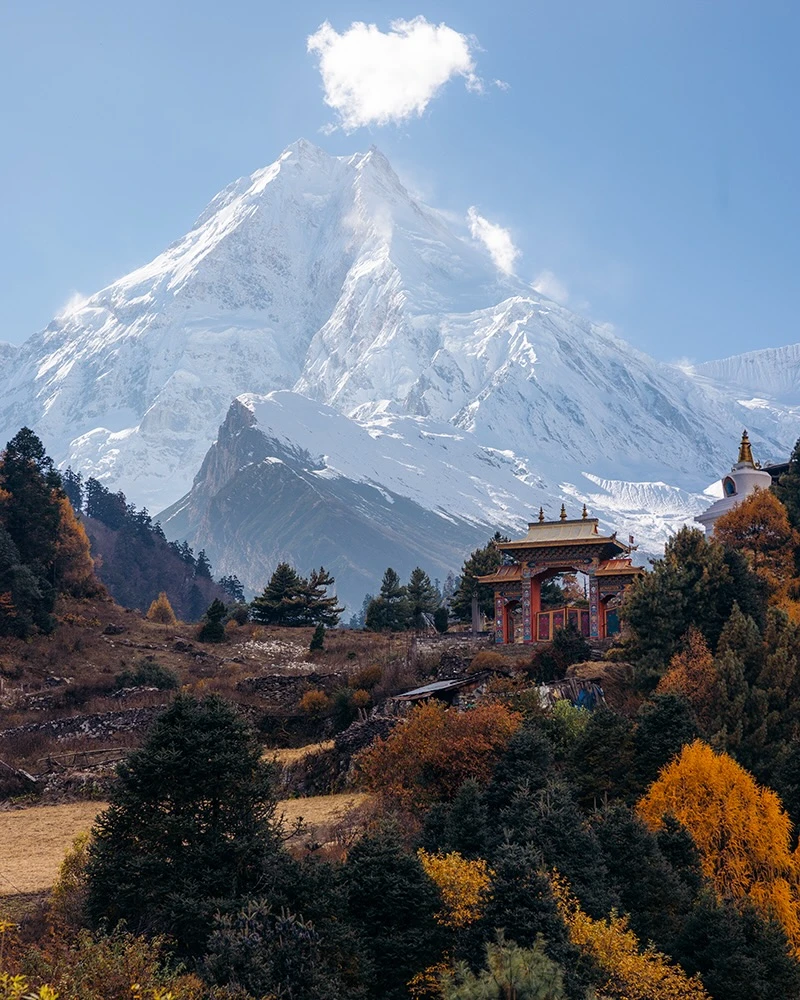
Namrung at 2,630 metres offers the first genuinely close view of Manaslu's upper section above the ridgeline to the north. In the hour before sunset, the mountain caught a light that turned the snow on the upper face from white to a pale orange. Several of us sat on the tea house terrace in silence, watching it happen.
Day 6: Namrung to Lho (3,180m)
Ribung Monastery sits above the trail between Namrung and Lho in a position that appears to have been chosen for its commanding view of the valley below and the peaks above simultaneously. The monastery is active, not a ruin, and the visit felt like a genuine introduction to a working religious community rather than a tourist stop. Padam translated a brief exchange with one of the monks about the monastery's history and the annual festival cycle. The conversation was ten minutes long and more informative than anything I had read about the region beforehand.
Lho at 3,180 metres is where the high-altitude portion of the circuit begins to assert itself. The air is noticeably thinner, the temperature dropped sharply after sunset, and the wood-burning stove in the tea house dining room became the social centre of the evening in a way it had not been at lower altitudes.
Day 7: Lho to Sama Gaon (3,530m) and Rest Day
Sama Gaon is the largest settlement in the upper Manaslu region, and the designated acclimatisation stop on any responsible itinerary. The rest day here is not a luxury. It is the reason most people complete the trek without serious altitude illness. Sleeping at 3,530 metres for two nights before ascending further gives the body the adjustment time the altitude profile demands.
On the rest day, I joined a small group for the optional hike to Manaslu Base Camp at approximately 4,800 metres. The walk takes four to five hours return from Sama Gaon, and the views of the Manaslu Glacier and the southern face of the mountain from the moraine above the base camp are the most dramatic of the entire circuit. The route is straightforward, and the acclimatisation benefit of the additional altitude gain and return descent is real. Padam recommended it specifically for this reason rather than as a sightseeing option.
Sama Gaon's monastery is well-maintained, and the community around it is cohesive and welcoming. An elderly man in the tea house courtyard invited several of us in for butter tea. The tea, which is made with yak butter and salt, is an acquired taste that rewards acquisition. I drank three cups and felt better for it.
Day 8: Sama Gaon to Samdo (3,860m)
The landscape above Sama Gaon transitions from the green and forested middle Himalaya to something closer to a high-altitude plateau. The vegetation becomes sparse, the wind picks up, and the visual register shifts towards the austere. Samdo at 3,860 metres is a small settlement of stone buildings with yaks grazing in the surrounding meadows and a tea house that operates with a pragmatic focus on warmth and calories.
Padam conducted a formal health check that evening: pulse oximeter readings for all four trekkers, questions about headaches, appetite, and sleep quality. Everyone was cleared. He set the departure time for the following morning at 4:30 am to reach Dharamsala before the afternoon wind on Larkya La.
Day 9: Samdo to Dharamsala (4,460m)
Dharamsala is three to four hours from Samdo and sits below the Larkya Glacier at 4,460 metres. It is a staging post rather than a village: a collection of basic lodges with very limited menus, minimal electricity, and a view directly up to the pass that makes the following day feel both imminent and serious.
I was nervous. This is not a particularly interesting observation, but it is an honest one. Padam noticed and was direct about it in a way that helped considerably. He had crossed Larkya La over a hundred times, he said. The pass required attention, appropriate clothing, and a slow pace. It did not require any skill I did not already have. We ate dinner early, confirmed layers, and were in sleeping bags by 8 pm.
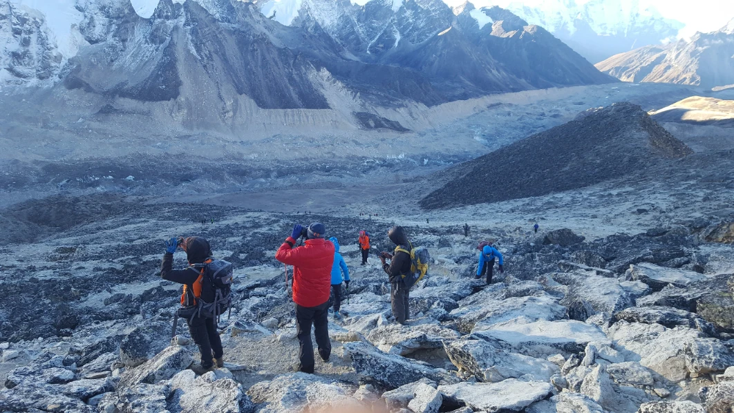
Day 10: Larkya La Pass (5,160m) and Descent to Bimthang (3,720m)
Departure at 4:30 am in darkness and minus eight degrees Celsius. The trail from Dharamsala to the pass climbs approximately 700 metres over four to five hours on a surface that transitions from packed earth to loose scree to hard ice in the final section below the summit ridge. Trekking poles are essential. Microspikes are necessary in late season or after recent snowfall, and Hiking Nepal, or maybe it's just the guide who carried them for us.
The physical experience of climbing to 5,160 metres is unlike anything below 4,500 metres. Each step on the upper section requires a deliberate decision. The body does not move automatically. The air delivers less oxygen per breath than the lungs expect, and the gap between exertion and recovery narrows to almost nothing. Padam walked slightly ahead, set a pace that was almost frustratingly slow, and stopped every fifteen minutes without being asked.
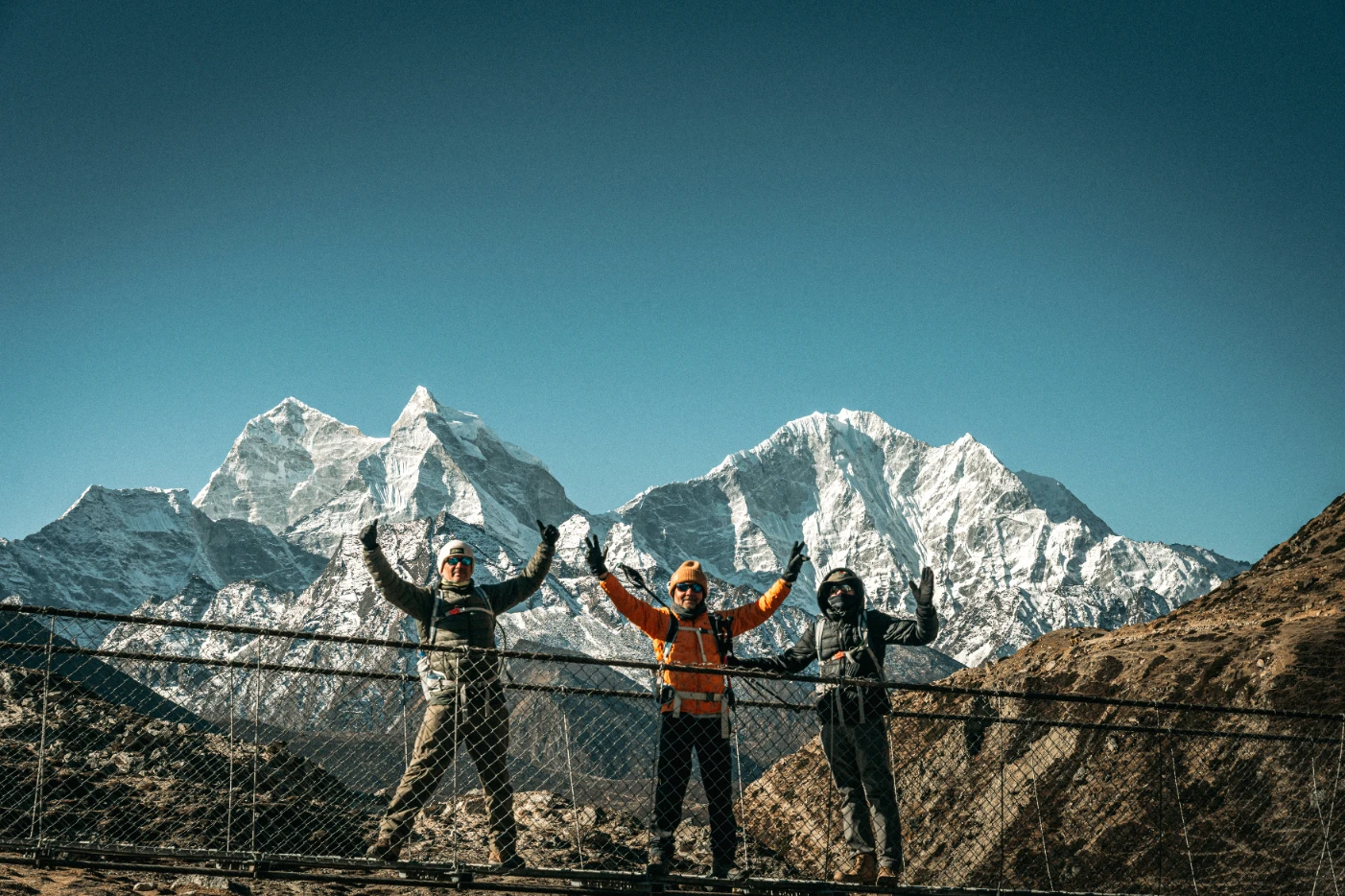
The summit ridge is marked with prayer flags in multiple colours, weathered by wind to a translucency that makes them look very old. The view from the pass covers Himlung Himal, Cheo Himal, Kang Guru, and the white expanse of the Larkya Glacier below the approach route. To the west, the descent drops into the Dudh Khola valley and the green lower country that the trail has been climbing away from since Day 1.
I will not attempt to describe the emotional register of standing there accurately. It was large, it was cold, and it involved something close to tears that I attributed to the wind.
The descent to Bimthang covers over 1,400 metres in altitude loss over five to six hours. It is where the knee makes itself known. The trail is steep, loose in sections, and long in a way that tests a different set of muscles from the ascent. Bimthang at 3,720 metres is a wide open valley with a small cluster of tea houses, glacial lakes reflecting the sky, and yaks moving slowly across the far meadow. We arrived in the mid-afternoon, ate soup, and did not move again until dinner.
Day 11: Bimthang to Tilije (2,300m)
The descent through the rhododendron forest below Bimthang has a quality of release to it. The altitude is dropping, the air is thicker, the temperature is warmer, and the hardest physical challenge of the trek is behind you. The forest in spring bloom is the Manaslu circuit's answer to the Poon Hill approach: successive waves of red, pink, and white rhododendron at different altitude bands, covering the hillside in colour.
Tilije is a traditional Gurung settlement with stone houses arranged around a central path and an atmosphere that has not been substantially altered by trekking tourism. The tea house owner's daughter was learning English from a workbook at the dining table when we arrived, and she tested her vocabulary on us systematically throughout dinner.
Day 12: Tilije to Tal (1,700m)
The Marsyangdi River runs alongside the final section of the circuit before it joins the Annapurna Circuit trail near Besisahar. The walking is easy, the gradient is gentle, and the contrast between this section and the terrain above the pass is stark enough to feel almost celebratory.
Tal at 1,700 metres has hot showers, reliable electricity, Wi-Fi, and cold beer. All four trekkers stood under hot showers for longer than was strictly necessary. The celebratory dinner included fresh trout from the river, which the tea house owner caught that afternoon, and the first cold drink since Soti Khola.
Day 13: Tal to Besisahar and Drive to Kathmandu
The final morning walk to the road at Syange or Besisahar depends on the jeep arrangement. Hiking Nepal coordinated the return vehicle to collect us at Besisahar in the morning. The drive back to Kathmandu takes six to seven hours along the Prithvi Highway. The mountains that had been the entire visual world for thirteen days receded into the background as the road descended towards the valley, and the city appeared in the late afternoon with its noise and its dust and its extraordinary density of human activity.
Day 14: Kathmandu
Hiking Nepal arranged a debrief at the Hotel Blue Horizon in Thamel on the final morning. This was a genuine conversation rather than a feedback form. What had worked, what had been difficult, and what I would recommend changing for other trekkers on the same circuit. The notes went into their operational file.
The celebration dinner that evening was at a Nepali restaurant within Thamel: as I got a bit tired of having dal bhat, I opted for some continental cuisine, and they abided and helped arranged at short notice. Padam brought a photograph he had taken on Larkya La and had printed at a shop in Thamel during the afternoon. It is on my desk now.
Challenges and How They Were Managed
Altitude
I experienced a mild headache and reduced appetite at Sama Gaon on the rest day, which resolved completely with additional hydration and an early night. Padam had pre-empted this with a hydration reminder at lunch and a recommendation to avoid the instant noodles on the tea house menu in favour of something with more nutritional content. The extra acclimatisation night I had requested at Namrung almost certainly contributed to a cleaner adjustment above 3,500 metres.
The Pass
The physical difficulty of Larkya La is real and not something to approach without preparation. The combination of altitude, low temperature, icy terrain, and a very long descent on the same day makes it the hardest single day on the circuit by a significant margin. Hiking Nepal's standard of providing microspikes, carrying supplemental oxygen, and conducting formal health checks the night before the pass crossing is the operational infrastructure that makes the pass manageable for a broader range of trekkers than the altitude figure alone might suggest.
Cold Nights Above 3,500m
The tea houses above Sama Gaon are cold. The walls are stone, the heating is a single wood or yak-dung stove in the communal dining room, and the bedrooms are unheated. A sleeping bag rated to minus ten degrees Celsius is the minimum appropriate specification. The down jacket worn inside the sleeping bag at Dharamsala was not an exaggeration.
Cultural Highlights
The Monasteries
Ribung Monastery above Lho, Sama Gompa in Sama Gaon, and the smaller gompa in Samdo collectively represent a depth of Tibetan Buddhist practice that has not been altered significantly by trekking tourism. The monasteries are not heritage sites managed for visitors. They are functional religious communities that tolerate and occasionally welcome respectful visitors. The distinction matters and is visible in the quality of access a knowledgeable guide can facilitate versus what an unaccompanied trekker would find.
The Communities
The Tibetan Buddhist villages of the upper circuit, particularly Lho, Sama Gaon, and Samdo, have a self-contained cultural character that is unlike anything on the main Everest or Annapurna corridors. The combination of traditional architecture, working agricultural practices, active religious institutions, and communities that have not optimised their lives around trekking revenue creates an atmosphere of genuine authenticity rather than performed culture.
Padam grew up in a village in the Gorkha district, speaks Nepali and Tamang as well as English, and had personal relationships with several tea house families on the circuit. The conversations he facilitated over the fourteen days were the most valuable part of the cultural experience, and they were conversations that would not have happened without him.
Packing List: What Worked and What I Missed
Item | Assessment | Notes |
| Waterproof trekking boots, broken in | Essential | No blisters. Non-negotiable. |
| Down jacket rated to minus 15 | Essential | Worn inside sleeping bag at Dharamsala |
| Merino wool base layers, two sets | Essential | Warm, odour-resistant, dries quickly |
| Trekking poles, two | Essential | The descents below the pass require them |
| Sleeping bag rated to minus 10 | Essential | Rented from Thamel. Performed well. |
| Headtorch with spare batteries | Essential | 4:30 am departure requires it |
| Power bank, 20,000 mAh | Essential | No charging above Sama Gaon |
| Pulse oximeter, personal | Recommended | Useful alongside the guide's unit |
| SPF 50 sunscreen | Essential | Applied every morning above 2,000m |
| Microspikes | Provided by Hiking Nepal | Required for late-season pass crossing |
| Knee brace | Did not bring | Should have. Long descents are hard on the knees. |
| Earplugs | Did not bring | Tea house walls are thin |
| Wet wipes, two packs | Essential | No showers for seven days above Jagat |
| Electrolyte sachets | Recommended | Daily above 3,500m |
| Personal first-aid basics | Essential | Blister plasters, paracetamol, and antihistamine |
Cost Breakdown for the Manaslu Circuit with Hiking Nepal
Expense | Cost (USD) | Notes |
| Manaslu Restricted Area Permit | USD 100 to 150 | Handled by Hiking Nepal |
| TIMS card | USD 20 | Included in the Hiking Nepal package |
| ACAP permit | USD 20 | Included in the Hiking Nepal package |
| Hiking Nepal package (guide, porter, accommodation, meals, transfers) | From USD 1,399 per person | Private departure, all-inclusive |
The Hiking Nepal all-inclusive price covers the licensed WAFA-certified guide, contracted porter at full IPPG welfare standards, all overnight accommodation on the circuit, all meals from Day 1 to Day 14, private jeep transfers from and to Kathmandu, all permit fees, supplemental oxygen, a full safety kit, and 24-hour emergency coordination. The figure that appears on comparison sites for budget Manaslu packages, often quoted between USD 800 and USD 1,200, typically excludes the permits, does not specify porter welfare standards, and does not include safety equipment. The question to ask any operator is not what the number is, but what the number covers.
Frequently Asked Questions
Is the Manaslu Circuit harder than Everest Base Camp? The maximum altitude of the Manaslu Circuit at Larkya La (5,160m) is lower than Kalapatthar on the EBC route (5,545m), but the circuit is harder overall. The daily ascent profiles are steeper, the trail surfaces are more variable, the infrastructure is thinner in the upper section, and the combination of a long summit day with the altitude makes the Larkya La crossing more demanding than a single day at EBC. Experienced trekkers who have done both consistently describe Manaslu as the more physically challenging route.
Do I need prior trekking experience for the Manaslu Circuit? Prior multi-day trekking experience is strongly recommended. The circuit is manageable for first-time high-altitude trekkers with appropriate preparation, but it is not an introductory route. The Poon Hill circuit or the Annapurna Base Camp trek, as a prior experience, gives you a realistic baseline for assessing your readiness.
What is the best time to trek the Manaslu Circuit? Spring (March to May) and autumn (September to November) are the two main seasons. Spring offers rhododendron blooms on the lower sections and stable weather through April. Autumn provides the best post-monsoon visibility and dry trails through October. Avoid the monsoon months of June through August and the winter months of December through February unless you have specific cold-weather trekking experience.
Can I trek Manaslu without a guide? No. The Manaslu Restricted Area Permit legally requires trekkers to travel with a licensed guide through a registered trekking agency. This requirement applies to all nationalities without exception and is enforced at permit checkpoints along the route.
How cold does it get on Larkya La Pass? At the pass in the early morning during spring or autumn, temperatures are typically between minus 8 and minus 15 degrees Celsius. Wind chill reduces this further. A down jacket, thermal base layers, windproof outer layer, warm hat, and gloves are required for the summit crossing regardless of the season.
Are there ATMs on the Manaslu Circuit? No. Withdraw sufficient cash in Kathmandu before departure. A budget of NPR 30,000 to 50,000 in local currency covers personal expenses, tips, hot showers, and charging fees for the full circuit duration. USD cash is also accepted at most tea houses above Jagat.
How do I prevent altitude sickness on the Manaslu Circuit? The most effective measures are the acclimatisation rest day at Sama Gaon, a consistent daily ascent rate that does not exceed 400 metres of sleeping altitude gain, daily hydration of three to four litres, avoidance of alcohol above 3,000 metres, and listening to your guide's assessment over your own optimism. Diamox (acetazolamide) can be used as a preventive measure and should be discussed with a GP before departure.
What is the food like above Sama Gaon? Dal bhat, instant noodles, noodle soup, fried rice, omelettes, porridge, and chapati are consistently available. Meat is not recommended above 3,500 metres due to the limited refrigeration and extended supply chains. Most tea houses can accommodate vegetarian requirements if notified in advance. Hiking Nepal communicates all dietary requirements to the tea house owners along the route before departure.
Would I Do It Again?
Without hesitation. The Manaslu Circuit is the best trek I have completed in Nepal, and I have now completed four. The combination of genuine altitude challenge, cultural depth, visual variety from subtropical river gorge to glacial high pass, and the relative quiet of the trail compared to the main Everest and Annapurna corridors makes it the circuit I would recommend to any experienced trekker looking for something that requires full attention and delivers it back with interest.
The quality of the Hiking Nepal team, specifically Padam's knowledge of the route, his management of the group's altitude adjustment, and his ability to facilitate genuine cultural exchange along the way, was central to the experience rather than peripheral to it. A different guide on the same route would have been a different trek.
I am already in contact with Hiking Nepal about the Upper Mustang for 2028 with Navaraj Wagle. That conversation began the morning after I got back from Larkya La.
Ready to Trek the Manaslu Circuit?
Hiking Nepal runs private guided departures on the Manaslu Circuit throughout the spring and autumn seasons. All departures include a licensed WAFA-certified guide, contracted porter at IPPG welfare standards, all accommodation and meals on the circuit, full permit handling, private vehicle transfers from Kathmandu, safety equipment, and 24-hour emergency support.
Spring 2026 departures are available from March through May. Autumn 2026 departures run from late September through November. Restricted area permit quotas apply, and early booking is advisable for October departures in particular.
Contact Hiking Nepal on WhatsApp at +977 9802342080 or at [email protected] to discuss your dates, fitness level, and the itinerary options that work best for you