300,000 trekkers on Annapurna this year. About 1,000 on Kanchenjunga. Let that sit for a moment. One in three hundred. On the trail to Pangpema, the north base camp of the world's third-highest mountain, you might pass three or four other trekking groups across your entire 22 days. On a busy Annapurna Circuit morning in October, you pass that many in the first hour after breakfast.
The Kanchenjunga Circuit is not a secret. It has been open to foreign trekkers since 1988. It sits in the eastern corner of Nepal, where the country nudges up against the Indian state of Sikkim and the Tibetan plateau. It takes you to the base of an 8,586-metre mountain from two completely different directions, through landscapes that shift from subtropical cardamom groves to glacial moraine to Tibetan Buddhist villages where the architecture has not changed in two centuries. It is, by almost any measure, the finest long-distance trek in Nepal. And almost nobody does it.
If you have already walked the Annapurna Circuit, stood at Everest Base Camp, and started wondering whether Nepal has anything left that feels genuinely unvisited, this is what you have been looking for.
What the Kanchenjunga Circuit Actually Is
The circuit is a loop around the Kanchenjunga massif, visiting both the north and south base camps in a single continuous trek. Most operators run it in 19 to 22 days, covering roughly 200 to 220 kilometres of trail.
The route begins at Taplejung in the far east of Nepal, accessible by a 45-minute flight from Kathmandu to Bhadrapur, followed by a seven to nine-hour jeep drive through the mid-hills. The drive passes through Ilam, where the terraced tea gardens are a different shade of green from anything in the high mountains.
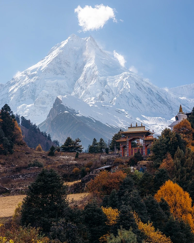
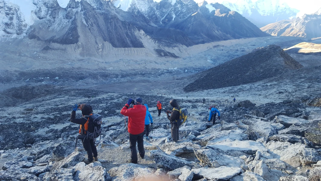
The circuit divides into two sides. The north approach follows the Tamor and Ghunsa rivers upstream through an increasingly dramatic gorge, past the Tibetan Buddhist villages of Phale and Ghunsa, past the yak pastures of Khambachen and the windy plain of Lhonak, to Pangpema at 5,143 metres. Here, the north face of Kanchenjunga fills the sky directly in front of you. Not a distant white triangle. The actual mountain is close enough to read the texture of its glacier.
The south approach crosses back over the Mirgin La Pass at 4,480 metres and arrives at Tseram and then Oktang, where the southern amphitheatre of the massif opens up. At Oktang, every visible peak surrounding you sits above 7,500 metres. This comparison does not apply to any other trekking destination in Nepal.
The circuit traditionally runs north first, then south, because the north approach provides better progressive acclimatisation before the higher passes. We run it north to south and have found the acclimatisation profile to be significantly better managed this way.
Why It Stays Empty
It is genuinely remote. Getting to the trailhead takes two days. The trail infrastructure is basic, particularly on the south side. You sleep on wooden beds. You eat dal bhat and noodle soup. You charge your phone when there is a socket. This is the thing that sorts the serious from the casual.
It requires a restricted area permit. The Kanchenjunga Conservation Area is restricted. You need a minimum of two trekkers and a licensed guide, plus the Restricted Area Permit at USD 20 per person per week, plus the KCAP permit at approximately USD 20. These requirements mean every person you meet on the trail made a deliberate decision to come here.
Nobody writes about it properly. The Kanchenjunga Circuit does not have the same travel media saturation as Everest or Annapurna. There are no Instagram posts with 80,000 likes from Pangpema. The mountain has not been turned into a brand. This is, from a trekker's perspective, precisely the point.
The North Side: Pangpema and the Face That Fills the Sky
Below Sekathum, you walk through cardamom country. The smell of it in the air on warm mornings is one of those sensory details that experienced Nepal trekkers keep describing years after the trek. You will be invited into houses. You will be offered tongba, warm fermented millet beer served in a wooden vessel with a bamboo straw. Refusing is impolite. Accepting is the beginning of a conversation.
Ghunsa at 3,415 metres is the circuit's most important village. It is the cultural heart of the Tibetan Buddhist community in this part of eastern Nepal and the acclimatisation base before the serious altitude gain begins. Spend two nights here. Walk to the Yamatari Glacier on your rest day afternoon. Sit with the monastery's morning prayers if you wake early enough.
Khambachen at 4,050 metres is where Jannu (Kumbhakarna) at 7,710 metres dominates the skyline. Most trekkers anywhere in Nepal never see Jannu. From Khambachen, it is the most prominent peak visible, a severe wall of rock and ice that mountaineers call one of the most technically demanding faces in the Himalaya. You see it from the teahouse door.
Lhonak at 4,780 metres is a windy, sandy plain. The vegetation is gone. The landscape is Tibetan in character, vast and arid, the horizon entirely occupied by mountain. Sleep here. Wake before dawn. Walk the three-hour round trip to Pangpema.
At Pangpema, the north face of Kanchenjunga sits directly above you. The glacier runs from the summit toward where you stand, close enough to hear the creak of ice. Yalung Kang at 8,505 metres is visible to the left. Kumbhakarna frames the right. Sunrise at Pangpema illuminates the massive mountain walls slowly, revealing textures of snow, rock, and ice rarely seen elsewhere. There is no queue. There is no teahouse. There is the mountain, and there is silence.
The South Side: Oktang and the Amphitheatre Above 7,500 Metres
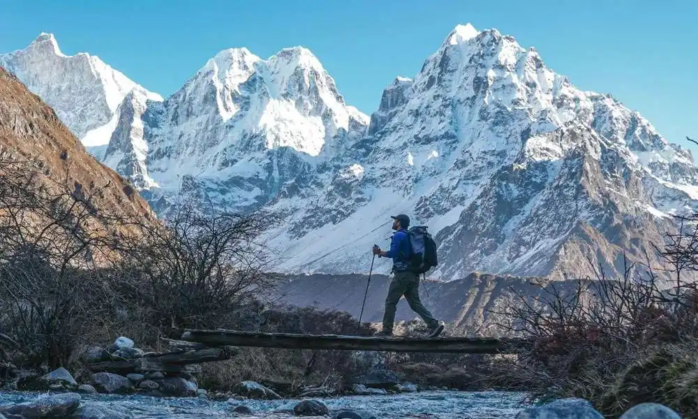
Cross the Mirgin La at 4,480 metres, and you descend into a different Nepal. The south approach is greener, wetter, and more physically demanding on the descent. The Simbua Khola valley is carved deep, and the trail follows it through forest that becomes progressively denser as the altitude drops.
Oktang, at approximately 4,730 metres, is the south base camp viewpoint. The cirque surrounding it has every visible peak sitting above 7,500 metres. Kanchenjunga's south face, Koktang at 6,147 metres, Rathong at 6,679 metres on the Sikkim border, the massifs of Kabru and Yalung Kang pressing in from both sides. The Yalung Glacier sprawls below, and the noise of it, periodic groans and cracks of shifting ice, is the soundtrack of an afternoon spent sitting still enough to hear.
Most accounts describe the north side as the circuit's highlight. We disagree. The north face is more dramatic as a single object. The south side is more complete as an experience: the landscape, the culture, the glacier, the viewpoint from Oktang. Give the south side the time it deserves. Do not rush it.
The People of the Trail
The lower valleys are the Limbu and Rai country. These are among Nepal's oldest indigenous communities, part of the Kirant culture that predates the Hindu kingdoms in the hills. The Limbu follow Kirant Mundhum, a belief system rooted in oral tradition and connection to ancestors. It coexists here with Buddhism and animism in a way that has not been rationalised into a tourism product. Nobody is performing culture for your camera.
Tongba is the right introduction. The bamboo straw through the warm millet works like a slow conversation. Accept the offer. Sit for longer than you planned.
As the trail climbs toward Ghunsa, the cultural character shifts to Tibetan Buddhist. The villages of Phale and Ghunsa are built in the Tibetan style with flat roofs, prayer wheels, and chortens at the village boundaries. The monastery at Ghunsa holds morning prayers that have continued without interruption through every disruption of the past century.
Kanchenjunga, in Tibetan, means Five Treasures of the Snow, referring to the five summits and the five repositories of God: salt, gold, turquoise, and sacred scriptures, which local tradition holds the mountain to contain. The summit was first climbed in 1955 by Joe Brown and George Band, and by custom, the climbing party left the final metres unclimbed out of respect for local belief.
How Hard Is This Trek, Really?
The Kanchenjunga Circuit is harder than the Everest Base Camp. Harder logistically, harder physically, and harder in terms of what happens if something goes wrong. This is not said to discourage you. It is said because the experienced trekker who has done EBC needs to update their assumption before they pack.
Duration: EBC and back is typically 14 days. Kanchenjunga is 19 to 22 days. This is not just more days. It is more consecutive days at altitude, more cumulative fatigue, and more exposure to weather events.
Altitude profile: The circuit involves multiple days above 4,500 metres in a row, including the pass crossings. The acclimatisation requirements are serious and must not be rushed.
Trail quality: Above Khambachen on the north side and above Tseram on the south, the trail is rough. Landslide sections, loose moraine, and paths that require attention and care.
Emergency access: Helicopter evacuation is possible but requires more time to organise than on the EBC corridor. Hold the right insurance and take altitude sickness symptoms seriously.
You need previous trekking experience above 4,000 metres. You need genuine fitness from several months of consistent training. And you need the right operator.
What the Teahouses Are Actually Like
Nobody tells you this clearly. On the north side, teahouses from Ghunsa upward are basic but functional. On the south side, Tseram and Ramche offer shelter and meals but very little beyond that. No wifi above Ghunsa. No bakeries. No espresso machines. A menu of four to six dishes, depending on what the porter brought last week. A dining room where you share dinner with your guide, because that is how it works out here.
A good sleeping bag is not optional. Rated to a minimum of -15 degrees Celsius.
This is the experience. The trekker who spends Kanchenjunga nights eating dal bhat with their guide by firelight is having a fundamentally different relationship with the trail than the one who spends EBC nights browsing Instagram in a heated lodge. This is what Nepal trekking felt like on the EBC route in the 1980s. It does not feel like that anymore. But it still feels like this here.
The Best Time to Trek Kanchenjunga
Two seasons. Everything outside them is a gamble.
Spring (late March through May): April and May are the prime months. The lower rhododendron forests are in bloom from 3,000 metres to the treeline. The weather above 4,000 metres is generally stable and clear. This is the season for colour and wildlife sightings in the lower forests.
Autumn (October through mid-November): Post-monsoon air clarity in October is exceptional. The views from Pangpema and Oktang in October, with the atmosphere washed clean by months of monsoon rain, are as good as Himalayan views get. October nights at Lhonak will be cold, but the sky at that altitude in that season contains more stars than you have seen anywhere.
Our recommendation: October for view quality and photography. April for colour and the sensory experience of the lower trail. Neither is crowded.
Permits: What You Need and What We Handle
- Restricted Area Permit (RAP): USD 20 per person per week for the first four weeks. Issued by the Department of Immigration through a registered trekking agency. Cannot be obtained independently.
- Kanchenjunga Conservation Area Project (KCAP) Permit: approximately USD 20 for foreign nationals.
- TIMS Card: standard trekker registration, processed as part of our agency booking.
We handle all three permits. You send us your passport details. Everything is processed before your departure date and carried by your guide throughout the expedition.
Kanchenjunga vs Everest Base Camp: An Honest Comparison
The EBC route is the finest introduction to Himalayan trekking that exists. None of that changes. But the EBC trail in October carries tens of thousands of trekkers per season. The teahouses at Namche are restaurants. The acclimatisation days have wifi.
The Kanchenjunga Circuit is what the EBC route used to feel like. This is the phrase that experienced Nepal trekkers keep using after completing it. The specific advantages:
- You see two base camps of a single massif from completely different perspectives, across three weeks of approach.
- The cultural landscape is richer and less mediated. The Limbu and Rai communities have not been through forty years of intense trekking tourism. The Tibetan Buddhist villages are intact. Nobody is selling you a Kanchenjunga keyring.
- The wildlife is more visible. The Kanchenjunga Conservation Area is WWF-classified as a Global Ecoregion and contains red panda, snow leopard, Himalayan black bear, blue sheep, and musk deer.
The honest disadvantage: the EBC route is logistically simpler, the teahouses are more comfortable, and the emergency response is faster. Kanchenjunga requires more preparation and a better operator.
Hiking Nepal on the Kanchenjunga Circuit
We know eastern Nepal. This is not a statement that every Nepal trekking company can make honestly. The Kanchenjunga region requires guides with specific local knowledge, not generalists who know EBC well and have done Kanchenjunga twice.
Our guides for Kanchenjunga hold Expedition-level NTB certification and have personal experience on both sides of this circuit across multiple seasons. They know when the afternoon weather pattern means you push to the next lodge and when it means you stop and wait. These guides are not available on the EBC trail.
Our 22-day circuit itinerary includes two acclimatisation nights at Ghunsa, a proper rest day at Khambachen, and a second summit attempt at Pangpema as a weather contingency. We do not rush this circuit. Our groups are small, with a maximum of eight trekkers per guide, with a preference for four to six.
Contact Hiking Nepal at +977 9802342080 or [email protected] to check 2026 & 2027 availability for Kanchenjunga Circuit departures. The spring season is limited. Autumn season books early.
Frequently Asked Questions
Is the Kanchenjunga Circuit harder than Everest Base Camp?
Yes, in most respects. It is longer (19 to 22 days versus 14 for EBC), the trail quality is more demanding above Khambachen and above Tseram, and emergency access is more limited. Previous trekking experience above 4,000 metres is required. It is not a beginner route.
How many trekkers do the Kanchenjunga circuit per year?
Approximately 1,000. The Annapurna region receives over 300,000 annually. The Everest region receives over 35,000. You will likely pass fewer than ten other trekking groups on a full 22-day circuit in the main season.
Can you do the Kanchenjunga circuit as a teahouse trek?
Yes, in spring and autumn. Teahouses operate throughout the main route during these seasons. The facilities are basic: wooden beds, limited menus, and no wifi above Ghunsa. A sleeping bag rated to minus 15 degrees Celsius is essential. Camping above Ghunsa is also available through our agency.
What permits do you need for Kanchenjunga?
Three: the Restricted Area Permit (USD 20 per person per week), the KCAP permit (approximately USD 20), and the TIMS card. A minimum of two trekkers and a licensed guide is required. Hiking Nepal processes all permits before your departure. You cannot obtain the RAP independently.
What is the best time to do the Kanchenjunga circuit?
April to May for spring (rhododendron bloom, good visibility) and October to mid-November for autumn (exceptional air clarity, best photography conditions). October is the single best month for maximum visibility at both base camps.
Is the Kanchenjunga circuit worth it for someone who has done EBC?
Yes. The comparison almost every trekker makes after completing it is that Kanchenjunga is what the EBC route felt like before the trekking infrastructure scaled. The cultural richness is greater, the solitude is genuine, and seeing a single massif from two opposite base camps across three weeks is structurally unlike anything on the popular routes.
The Kanchenjunga Circuit is what Nepal's mountains still are in the east, before the teahouses became hotels and the trails became managed experiences. It takes you longer to reach and requires more of you when you are there. The 1,000 trekkers who come each year are not the ones who chose it because it was convenient. They are the ones who looked at a map and followed the river east until the mountain filled the sky and nobody else was there. We know this circuit well. We would like to take you through it. Book your next trip with us and get to experience Kanchenjunga in the best possible way.