What Happened
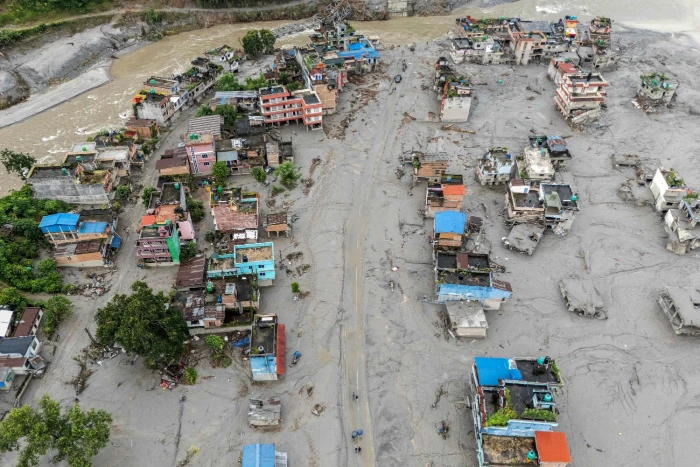
On the morning of Wednesday 26 August 2026, a catastrophic flash flood tore down the Bhote Koshi River from the Tibetan side of the border into Nepal's Rasuwa district. Water levels in the Trishuli River are reported to have risen by as much as nine metres in half an hour, with the flood wave moving through its first stretch at roughly 193 kilometres per hour. Scientists investigating the cause have pointed to an ice-and-rock avalanche from a glacier that blocked the Lhende Khola, a tributary on the Nepal side, and then released a sudden surge downstream, a mechanism separate from ordinary monsoon rainfall. A disaster risk reduction specialist at ICIMOD noted that the Lhende Khola has now flooded twice in fourteen months. Two days later, on 28 August, a barrier lake formed by debris from the initial landslide broke its banks, briefly halting rescue operations in both Nepal and China on fears of a second surge, and authorities are continuing to monitor two lakes in the area, warning that flood risk will persist until they are fully drained.
This is one of the deadliest natural disasters to hit Nepal in decades, and the scale of it has grown daily since the flood struck. This is not a story about a damaged trekking trail. It is, first and foremost, a story about a catastrophic loss of life along a river corridor that happens to also be a trekking and pilgrimage route.
Where the Damage Is from the flash flood
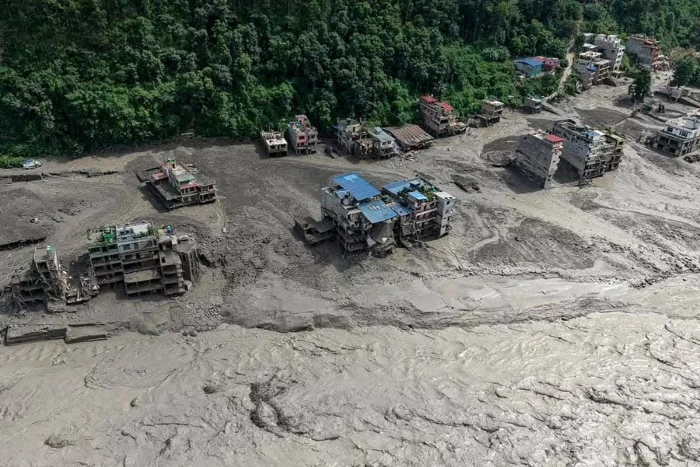
The flood entered Nepal through Timure, a border settlement, then swept through Syabrubesi and down the Trishuli and Narayani river systems into Nuwakot, Dhading, Gorkha, Chitwan, and Tanahun. Authorities ordered residents along riverbanks and in low-lying areas of all six districts to move to higher ground in the days following the flood. Strikingly, the casualty count is not concentrated where the water first hit. Chitwan, far downstream from Rasuwa, accounts for the largest number of recovered bodies of any single district, with Nawalparasi East a close second, against a comparatively small number in Rasuwa itself, a reflection of how far downstream the flood's destructive force carried.
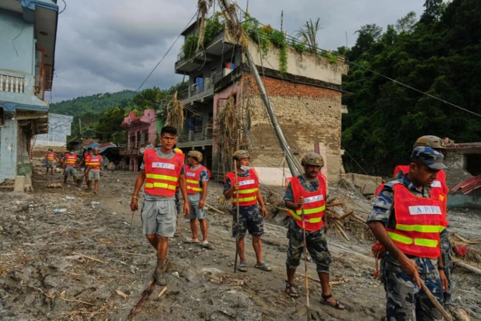
Physical infrastructure losses are severe and still being tallied. Officials have confirmed that 32 bridges and nearly 25 miles of road were destroyed, including the entire road linking Betrawati in Nuwakot to the Rasuwagadhi border crossing with Tibet. Fourteen hydropower and solar installations were damaged, and at least six major hydropower projects, including Upper Trishuli-3A and 3B, Rasuwagadhi, and Chilime, have reported serious damage. The United Nations Development Programme has produced a preliminary estimate of more than 2.4 million tons of debris across the affected area, made up of building material, household belongings, vegetation, rock, and sediment, which UNDP has described as a marker of the scale of destruction and the scale of the clean-up challenge facing these communities. Nepal's government is reportedly working on a detailed damage assessment, with early reconstruction cost estimates for the Bhote Koshi corridor alone running as high as five billion dollars. Twenty schools across three districts were damaged. Nepal's Cabinet has declared the flood-hit areas disaster zones for three months.
Search and Rescue after the flood
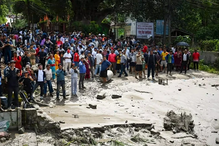
As of the most recent update available at time of writing, Nepal's National Disaster Risk Reduction and Management Authority reported a death toll of 1,114, with roughly 4,500 people, including hundreds of foreign nationals, still unaccounted for across Nepal and China combined. Nearly 12,000 people have been rescued in Nepal to date. A Nepal Police situation report from earlier this week detailed the scale of the mobilisation: close to 7,900 police personnel deployed to the response, of whom 65 have themselves been affected by the disaster and 25 remain out of contact. Of the missing in Nepal, roughly 580 recovered survivors and several hundred of those still unaccounted for are foreign nationals, drawn from at least 38 countries. Officials investigating the missing list have noted that pilgrims travelling the Rasuwagadhi route toward Kailash Mansarovar during peak late-August pilgrimage season, and workers at hydropower project sites along the corridor, make up a large share of those still unaccounted for.
Some communities in Rasuwa and Nuwakot are now facing shortages, or a total lack, of aid supplies, according to Nepal's disaster authority, even as the immediate search continues. A CNN report this week, citing a UN-linked review, noted that warning signs were visible ahead of the flood, a finding likely to shape how Nepal and its neighbours approach glacial lake monitoring going forward, though that is a longer-term policy question rather than one that changes anything for a trekker today.
We are not going to speculate further on casualty figures here. They are being updated daily by Nepal's disaster authorities and by international wire services, and readers wanting the most current count should go directly to those sources rather than this page.
Current Status of Affected Trekking Routes
Langtang Valley Trek. Syabrubesi, the standard road-end trailhead for this route, sits at the confluence that took direct structural damage, and the approach road above it has been damaged in multiple sections. As of late August, trekking operators working this region reported all activity in Langtang suspended, with the area expected to remain physically inaccessible for a minimum of three to four weeks from the flood date. What is genuinely not yet known is the condition of the trail itself above Syabrubesi, toward Lama Hotel, Langtang village, and Kyanjin Gompa. Reporting so far confirms extensive damage to the lower road and river corridor but does not include a full engineering assessment of the upper valley trail. Until that assessment exists, any claim that the Langtang trail itself is either fine or destroyed is guesswork, and we are not going to offer either.
Tamang Heritage Trail. This route spends more time in the northern villages closer to Timure, nearer the point where the flood entered Nepal, and it sits closer to the areas of confirmed damage than the main Langtang Valley route. We would treat this as the most exposed of the three routes discussed here.
Gosaikunda. This is the one route in the district with a materially different picture. Gosaikunda's trailhead is Dhunche, not Syabrubesi. Dhunche sits higher above the river and short of the worst-hit stretch of the Bhote Koshi and Trishuli corridor, and the lakes themselves, along with the trail leading to them, were not in the flood's path. What is affected is the road used to reach Dhunche, which has seen partial reopening for small vehicles in the days since the flood. There is also a longer walking alternative that bypasses the damaged road network entirely, the traditional route from Sundarijal over Chisapani and Kutumsang to Gosaikunda, on foot from the rim of the Kathmandu Valley, though this adds several days to an itinerary and, in late August and early September, means walking through active monsoon conditions with the leeches, slippery stone steps, and low visibility that involves.
Everest, Annapurna, and Manaslu. These regions sit outside the Rasuwa-Nuwakot-Dhading-Gorkha corridor and have not been directly affected by this flood. This is a geographic fact about where the water went, not a certification that these trails carry no risk at all this season. Nepal's monsoon does not formally end until mid-September, and landslides, local road damage, and changeable trail conditions remain a normal seasonal risk on any Nepal trekking route independent of this specific disaster.
Road and Access Conditions
Access into and through the affected corridor has changed almost daily since 26 August, and anyone relying on a single snapshot, including this one, should expect it to be out of date within days. The Prithvi Highway, Nepal's main artery linking Kathmandu to Pokhara, was closed in the immediate aftermath and has since reopened, though the closure pushed a significant volume of traffic onto the alternative Hetauda to Kathmandu route in the interim. Limited road access between Kathmandu and Dhunche has resumed for small vehicles. Beyond Dhunche, toward Syabrubesi, Timure, and the Langtang trailheads, extensive damage continues to prevent normal travel, and the Rasuwagadhi border crossing into Tibet remains inaccessible entirely. The Galchhi-Nuwakot-Rasuwa-Syabrubesi road and the Mugling-Narayangadh road have both seen closures and partial reopenings as authorities clear debris and assess remaining structures. None of this should be treated as fixed. Road conditions in this corridor are changing week to week, sometimes day to day, as clearance work continues.
Official Advisories
The U.S. Embassy in Kathmandu has issued a sequence of disaster alerts since 26 August, and the guidance in the most recent of these remains unambiguous: do not travel to Rasuwa District, including Langtang, Gosaikunda, the Tamang Heritage Trail, Syabrubesi, Timure, or Rasuwagadhi, until authorities and your travel operator confirm safe access. On 29 August, the United States raised its overall Nepal travel advisory to its highest level, Do Not Travel, a designation it has applied jointly to Nepal and China given the cross-border nature of this disaster. The Embassy's standing safety instructions for anyone in or near the affected area are worth repeating in full because they are the kind of practical detail a trekker actually needs: stay away from riverbanks, low-lying areas, damaged bridges, and unstable slopes; never walk, swim, or drive through floodwater; do not enter the disaster area independently to search for a missing person; and if you are in an affected area, contact the Embassy through its official channels rather than by phone unless it is an emergency.
Nepal's own Department of Hydrology and Meteorology is the authoritative source for current flood and weather risk and can be reached at dhm.gov.np or by phone at 1155. For search and rescue matters specifically, Nepal's disaster hotline is 1234. The Nepal Tourism Board has said it is running an active effort to locate missing visitors, relay information to foreign embassies, and assist tour operators in rerouting or cancelling itineraries that touch the Rasuwa corridor. We would treat all of the above as more current and more reliable than any single blog or news article, including this one, and would encourage anyone personally affected or travelling soon to check these sources directly rather than relying on secondhand summaries.
What This Means If You Have a Trip With Hiking Nepal
If your Hiking Nepal booking is for the Langtang Valley Trek, the Tamang Heritage Trail, or Gosaikunda and is scheduled for the remainder of the autumn 2026 season, we will be contacting you directly, individually, rather than asking you to work this out from a blog post. That conversation will cover your specific departure date, the most current information we have on your specific route, and your options, which include rescheduling to a later date, transferring to an unaffected region such as Everest, Annapurna, or Manaslu for this season, or postponing to 2027 with no cancellation penalty attached to this event specifically. If you have not heard from us and believe you should have, please reach out to us directly rather than waiting.
If your booking is for Everest, Annapurna, or Manaslu, this event does not currently change your itinerary. The standard late-monsoon guidance we would give any client this time of year still applies, and we will flag anything specific to your dates if conditions change.
If you are holding a 2027 booking for the Langtang region specifically, we do not think it is honest to offer either reassurance or serious concern at this point, and we are not going to pretend otherwise for the sake of a tidy answer. What we can say is that a disaster of this scale, involving dozens of destroyed bridges, tens of kilometres of road, and reconstruction estimates already running into billions of dollars for the Bhote Koshi corridor alone, points toward a recovery measured in many months for road infrastructure, based on how comparable damage played out after Nepal's 2015 earthquake. Trekking trails have historically reopened well ahead of the roads serving them in past disasters, but no engineering assessment of the Langtang Valley trail itself has been published yet, and we will not speculate on your behalf. We will revisit your booking directly with you well ahead of your 2027 dates, once there is an actual assessment to base that conversation on rather than a guess.
If you are currently in Nepal, in or near the affected area, or unable to reach a family member or trekking companion who was in the region, please contact Nepal's disaster hotline at 1234, your embassy's emergency contact line, and our office directly. We would rather field a call that turns out to be unnecessary than have anyone hesitate to reach out.
How to Help
Several organisations with established operations in Nepal have active emergency responses running in Rasuwa, Nuwakot, and Dhading right now, addressing shelter, food, clean water, health services, and the early stages of recovery for communities that will need support long after the search for the missing has ended. CARE, UNICEF, World Vision, and the Nepal Red Cross Society are among the organisations currently running verified emergency response operations in the affected districts. We would encourage anyone who wants to help, whether or not you have any trip booked with us, to give through one of these established channels rather than informal appeals, and to prioritise this over anything related to future travel planning. The people in Rasuwa, Nuwakot, and Dhading rebuilding their homes and communities right now do not need Nepal's trekking industry's attention on next season. They need support this week.
This Page Will Be Updated
The figures, road statuses, and advisories in this piece reflect what was publicly confirmed as of 3 September 2026, eight days after the flood. Search and rescue operations are ongoing, casualty figures are still being revised upward, and no formal engineering assessment of the Langtang Valley trekking trail has yet been published. We will revise this page as that changes, and we will date each revision rather than silently editing it. If you are reading this more than a few days after the date above, please treat the casualty and access figures here as historical rather than current, and check the official sources linked above directly.
Last updated: 3 September 2026. This page is being revised as new information becomes available; earlier figures below have already been superseded once and will likely be revised again.